RSS feed source: US National Weather Service

Clearing skies and ample moisture have led to the development of patchy areas of fog across portions of the state this morning. Visibilities of less than one mile have already been observed along US 20/26 from Casper to Hiland. Other locations such as Star Valley have seen fog develop, leading to reduced visibilities of less than one mile as well. * WHAT…Patchy areas of fog leading to decreased visibilities of less than one mile. * WHERE…Portions of Western, Southern, and Central WY. Locations such as Star Valley, Jackson Hole, Green River Basin, Wind River Basin, and Natrona County. * WHEN…Through 10 AM Thursday. * ADDITIONAL DETAILS… If needing to drive through

Click this link to continue reading the article on the source website.

RSS feed source: US National Weather Service

Thursday, Nov 20, 2025 09:50 | 36 mins ago | By: EarthquakeMonitor

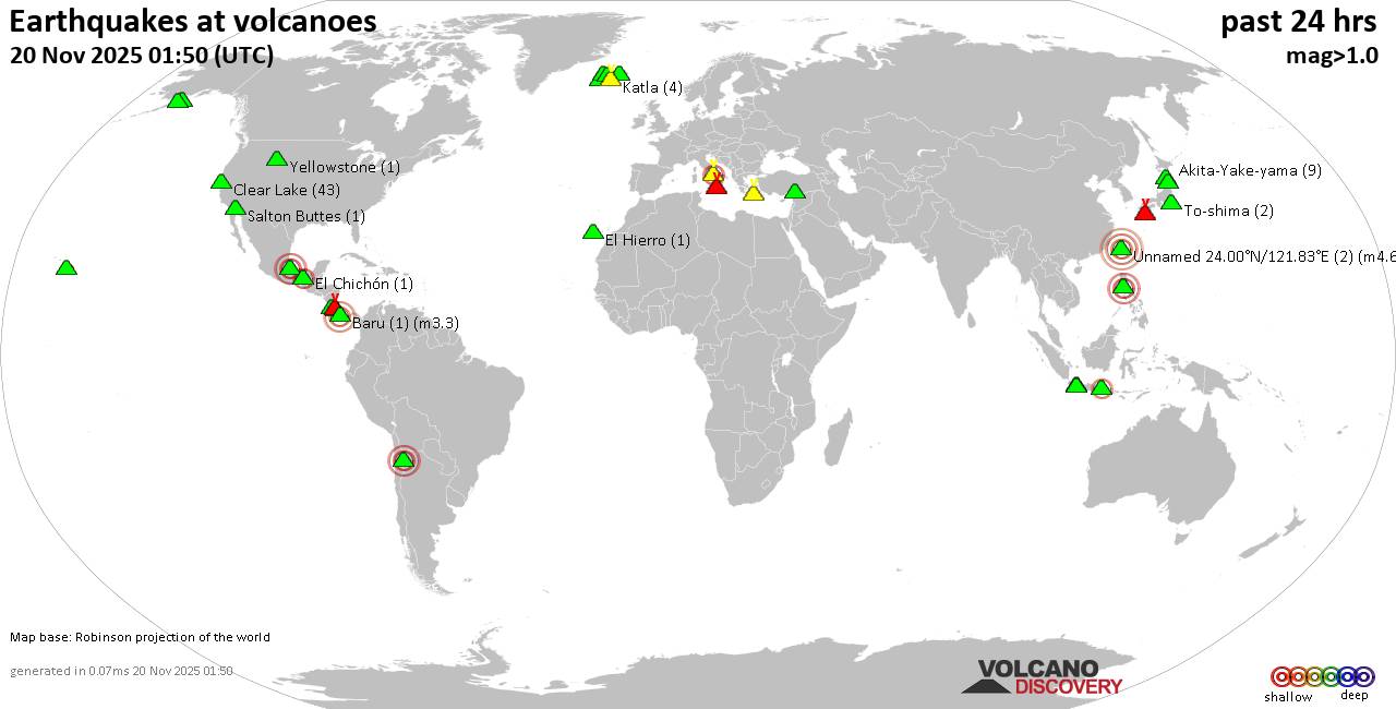
World map showing volcanoes with shallow (less than 50 km) earthquakes within 20 km radius during the past 24 hours on 20 Nov 2025 Number in brackets indicate nr of quakes.

Quakes detected near: Akita-Yake-yama (8 quakes between mag 0.2-1.1), Arayat (1 quake mag 3.0), Askja (3 quakes between mag 0.7-1.7), Baluran (1 quake mag 2.7), Baru (1 quake mag 3.3), Campi Flegrei (Phlegrean Fields) (57 quakes between mag 0.1-2.7)
Clear Lake (43 quakes between mag 0.2-2.1), Cleveland (1 quake mag 1.0), Cofre de Perote (1 quake mag 2.8), El Chichón (2 quakes between mag 2.0-2.2), El Hierro (1 quake mag 1.2), Eldey (4 quakes between mag 1.4-1.9), Hrómundartindur (6 quakes between mag 0.1-1.3), Irazu (1 quake mag 2.1), Katla (4 quakes between mag 0.0-1.4), Kawah Kamojang (1 quake mag 1.8), Kilauea (1 quake mag 1.9), Kirishima (3 quakes between mag 0.2-1.1), Koruhüyüğü (1 quake mag 1.8), Kukak (1 quake mag 1.9), Ljósufjöll (11 quakes between mag 0.1-1.9), Loki-Fögrufjöll volcano (5 quakes between mag 0.3-1.0), Maroa (1 quake mag 1.1), Maunaloa (2 quakes between mag 1.0-1.8), Ngauruhoe (1 quake mag 1.3), Papandayan (6 quakes between mag 1.9-3.3), Poas (1 quake mag 2.4), Prestahnukur (1 quake mag 1.2), Salton Buttes (1 quake mag 1.1), Santorini (1 quake mag 1.6), Shishaldin (5 quakes

Click this link to continue reading the article on the source website.
RSS feed source: US National Weather Service

Date and TimeMag
DepthDistanceLocationDetailsMap Oct 23, 10:08 pm (Istanbul)

4.0

7.1 km36 km (23 mi) to the NE 22 km south of Kahramanmaras, Kahramanmaras, Turkey 9 reportsInfoOct 19, 02:39 pm (Istanbul)

4.1

7 km82 km (51 mi) to the NW 39 km northeast of Kozan, Adana, Turkey 3 reportsInfoAug 13, 05:45 pm (Istanbul)

4.1

5.1 km71 km (44 mi) to the NW 38 km northeast of Kozan, Adana, Turkey 4 reportsInfoNov 28, 2024 10:12 am (Istanbul)

4.1

10.8 km101 km (63 mi) to the N 14 km east of Goksun, Kahramanmaras, Turkey 1 reportInfoOct 27, 2024 08:07 pm (Istanbul)

4.9

10 km78 km (49 mi) to the NW 26 km northeast of Kozan, Adana, Turkey 21 reportsInfoOct 19, 2024 02:41 pm (Istanbul)

4.5

10 km68 km (42 mi) to the NE 19 km east of Kahramanmaras, Kahramanmaras, Turkey 10 reportsInfoSep 7, 2024 09:31 am (Istanbul)

5.0

4.1 km43 km (26 mi) to the NE Kahramanmaras, 40 km northwest of Gaziantep, Gaziantep, Turkey 28 reportsInfoAug 7, 2024 05:33 am (Istanbul)

4.4

10 km82 km (51 mi) to the NW 24 km northeast of Kozan, Adana, Turkey InfoAug 7, 2024 05:32 am (Istanbul)

4.6

10 km85 km (53 mi) to the NW 16 km SSE of Feke, Turkey 11 reportsInfoJul 25, 2023 08:44 am (Istanbul)

5.5

13 km78 km (49 mi) to the NW 18 km NE of Kozan, Turkey 54 reportsInfoMar 23, 2023 12:19 pm (Istanbul)

5.3

10 km99 km (62 mi) to the N 6.2 km west of Goksun, Kahramanmaras, Turkey 14 reportsInfoFeb 7, 2023 06:13 am (Istanbul)

5.5

10 km119 km (74 mi) to the NE 14 km northwest of Besni, Adiyaman, Turkey 8 reportsInfoFeb 6, 2023 03:02 pm (Istanbul)

6.0

8.5 km103 km (64 mi) to

Click this link to continue reading the article on the source website.