RSS feed source: Volcano Discovery.com--Global earthquake monitor

Date and TimeMag
DepthDistanceLocationDetailsMap Oct 30, 2024 12:20 pm (GMT -1)

4.7

10 km47 km (29 mi) to the ESouthern Mid-Atlantic Ridge InfoFeb 16, 2023 04:10 pm (GMT -1)

4.5

10 km50 km (31 mi) to the SESouthern Mid-Atlantic Ridge InfoFeb 16, 2023 02:55 pm (GMT -1)

5.4

10 km61 km (38 mi) to the S Southern Mid-Atlantic Ridge InfoOct 1, 2022 05:12 am (GMT -1)

4.5

10 km11 km (7.1 mi) to the NSouthern Mid-Atlantic Ridge InfoSep 25, 2022 05:22 pm (GMT -1)

4.2

10 km77 km (48 mi) to the N Southern Mid-Atlantic Ridge InfoSep 14, 2022 05:28 pm (GMT -1)

4.6

10 km46 km (28 mi) to the NE Southern Mid-Atlantic Ridge InfoSep 14, 2022 03:39 am (GMT -1)

4.7

10 km79 km (49 mi) to the N Southern Mid-Atlantic Ridge InfoAug 31, 2022 01:59 am (GMT -1)

4.6

10 km72 km (45 mi) to the NE Southern Mid-Atlantic Ridge InfoAug 7, 2022 02:45 pm (GMT -1)

4.8

10 km45 km (28 mi) to the NE Southern Mid-Atlantic Ridge InfoJun 25, 2021 02:35 am (GMT -1)

4.6

10 km5.9 km (3.7 mi) to the SW Southern Mid Atlantic Ridge InfoSep 27, 2019 09:40 pm (GMT -1)

4.7

10 km92 km (57 mi) to the E Southern Mid-Atlantic Ridge InfoAug 14, 2019 06:51 pm (GMT -1)

4.7

10 km110 km (68 mi) to the SW Southern Mid-Atlantic Ridge InfoJul 6, 2018 02:17 pm (GMT -1)

4.7

10 km28 km (17 mi) to the N Southern Mid-Atlantic Ridge InfoMay 17, 2018 12:28 pm (GMT -1)

4.6

10 km70 km (44 mi) to the E Southern Mid-Atlantic Ridge InfoMay 17, 2018 12:22 pm (GMT -1)

4.7

10 km56 km (35 mi) to the NE Southern Mid-Atlantic Ridge InfoSep 17, 2017 12:30 pm (GMT -1)

4.9

10 km40 km (25 mi) to the N

Click this link to continue reading the article on the source website.

RSS feed source: Volcano Discovery.com--Global earthquake monitor

* WHAT…A long period southwesterly swell will result in an increased risk for sneaker waves and rip currents. * WHERE…Coastal North Bay Including Point Reyes National Seashore, San Francisco Peninsula Coast, and Northern Monterey Bay. * WHEN…Through Monday evening. * IMPACTS…Sneaker waves can unexpectedly run significantly farther up the beach than normal, including over rocks and jetties. Rip currents are typically more frequent and stronger in the vicinity of jetties, inlets, and piers. Swimmers should always swim near a lifeguard. * ADDITIONAL DETAILS…Greatest risk will be along southwest facing beaches. Coastal sections of Marin and Santa Cruz Counties. In particular southwest facing beaches, including but not limited to Stinson Beach, Santa

Click this link to continue reading the article on the source website.

RSS feed source: Volcano Discovery.com--Global earthquake monitor

* WHAT…Flooding caused by excessive rainfall is expected. * WHERE…A portion of west central Texas, including the following county, Crockett. * WHEN…Until 1245 AM CDT. * IMPACTS…Minor flooding in low-lying and poor drainage areas. * ADDITIONAL DETAILS… – At 1045 PM CDT, Doppler radar indicated heavy rain due to thunderstorms. Minor flooding is ongoing or expected to begin shortly in the advisory area. Between 0.75 and 1.5 inches of rain have fallen. – Additional rainfall amounts of 0.5 to 1 inch are expected over the area. This additional rain will result in minor flooding. – Some locations that will experience flooding include… Ozona, The Intersection Of Highway 163 And Ranch Road

Click this link to continue reading the article on the source website.
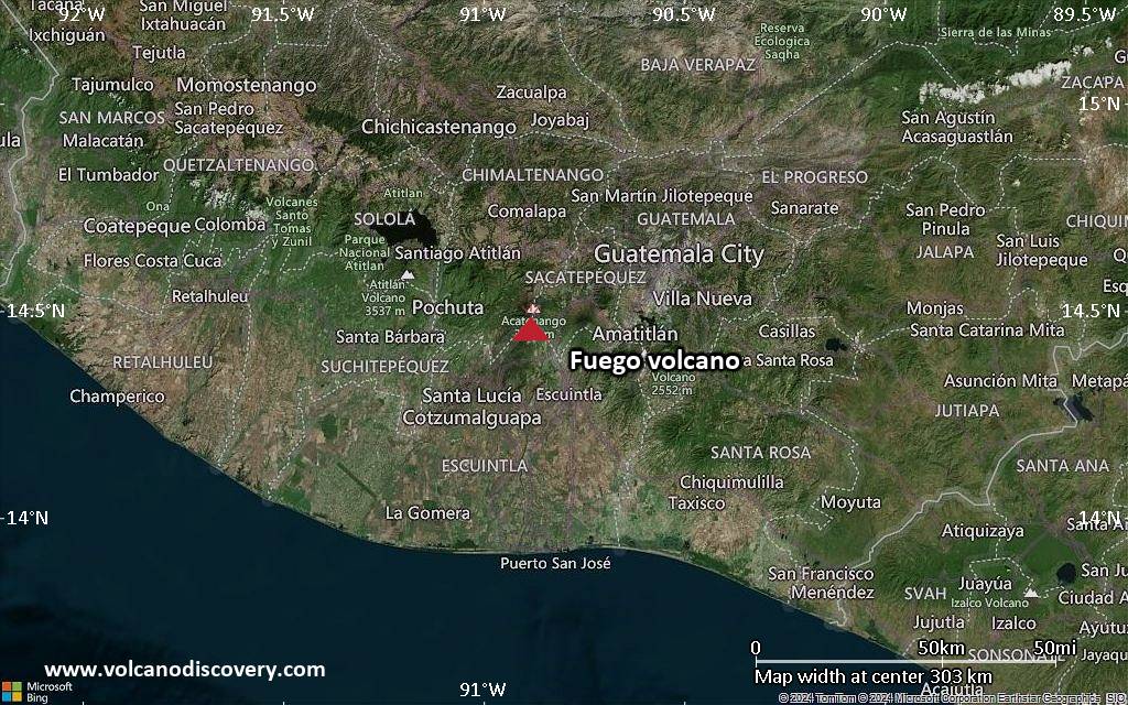
RSS feed source: Volcano Discovery.com--Global earthquake monitor

<!–div style="font-size:14px;text-align:center;border:3px solid blue;border-radius:5px;padding:3px;margin:5px;background:#eee"><a href="https://www.volcanoesandearthquakes.com/app/volcano-report.php?volcanoId=26" style="text-decoration:none" target="_blank" rel="noopener noreferrer nofollow" title="Share a volcano (activity) report, submit a photo or other interesting news!” onclick=”window.open(this.href,’Volcano Report’,’status=0,toolbar=0,location=0,directories=0,menubar=0,resizable=1,scrollbars=1,height=500,width=450′);return false”>Send Volcano Report</div–> Stratovolcano 3,763 m / 12,346 ft
Guatemala, 14.47°N / -90.88°W
Current status: erupting (4 out of 5) Fuego volcano eruptions:
1581, 1585, 1586, 1587, 1614, 1617, 1620, 1623, 1629, 1679(?), 1685, 1686, 1689(?), 1699, 1702, 1705, 1706, 1709(?), 1710,1717,1730, 1732, 1737, 1751(?), 1765(?), 1773(?), 1799, 1826, 1829, 1850(?), 1852(?), 1855, 1856, 1857, 1860, 1861(?), 1867(?), 1880, 1896, 1932, 1944, 1949, 1953, 1955, 1957, 1962, 1963, 1966, 1967, 1971, 1973, 1974, 1975, 1977, 1987, 1999, 2002 – ongoing
Typical eruption style
Dominantly explosive, construction of lava domes and extrusion of viscous lava flows. In near constant activity, at least during the past centuries.

Click this link to continue reading the article on the source website.