RSS feed source: USGS Earthquake Hazards Program
Time2025-08-12 10:02:06 UTC2025-08-12 10:02:06 UTC at epicenterLocation51.382°N 159.186°EDepth35.00 km (21.75 mi)
Click this link to continue reading the article on the source website.
RSS feed source: USGS Earthquake Hazards Program
Time2025-08-12 10:02:06 UTC2025-08-12 10:02:06 UTC at epicenterLocation51.382°N 159.186°EDepth35.00 km (21.75 mi)
Click this link to continue reading the article on the source website.
RSS feed source: USGS Earthquake Hazards Program
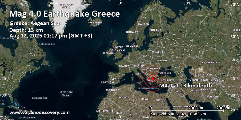
11 km (7 mi)
E of epicenter
(pop: 237)
IV: Light
Mount Athos 16 km (10 mi)
NW of epicenter
(pop: 1,050)
III: Weak
Chalkidikí, Central Macedonia 27 km (17 mi)
SW of epicenter
(pop: 1,900)
III: Weak
Chalkidikí, Central Macedonia 27 km (17 mi)
NW of epicenter
(pop: 3,270)
III: Weak
Chalkidikí, Central Macedonia 29 km (18 mi)
W of epicenter
(pop: 100)
III: Weak
Chalkidikí, Central Macedonia 33 km (20 mi)
SW of epicenter
(pop: 3,160)
III: Weak
Chalkidikí, Central Macedonia 38 km (24 mi)
W of epicenter
(pop: 2,710)
III: Weak
Chalkidikí, Central Macedonia 39 km (24 mi)
NW of epicenter
(pop: 1,060)
III: Weak
Chalkidikí, Central Macedonia 41 km (25 mi)
W of epicenter
(pop: 802)
III: Weak
Chalkidikí, Central Macedonia 44 km (27 mi)
NW of epicenter
(pop: 2,590)
III: Weak
Chalkidikí, Central Macedonia 49 km (31 mi)
W of epicenter
(pop: 2,980)
III: Weak
Chalkidikí, Central Macedonia 52 km (32 mi)
SW of epicenter
(pop: 1,930)
III: Weak
Chalkidikí, Central Macedonia 54 km (33 mi)
NW of epicenter
(pop: 538)
III: Weak
Chalkidikí, Central Macedonia 58 km (36 mi)
NE of epicenter
(pop: 2,470)
III: Weak
Click this link to continue reading the article on the source website.
RSS feed source: USGS Earthquake Hazards Program
Support us – Help us upgrade our services! We truly love working to bring you the latest volcano and earthquake data from around the world. Maintaining our website and our free apps does require, however, considerable time and resources.
We need financing to increase hard- and software capacity as well as support our editor team. We’re aiming to achieve uninterrupted service wherever an earthquake or volcano eruption unfolds, and your donations can make it happen! Every donation will be highly appreciated. If you find the information useful and would like to support our team in integrating further features, write great content, and in upgrading our soft- and hardware, please make a donation (PayPal).
Planned features:
Improved multilanguage supportTsunami alertsFaster responsivenessThanks to your past donations, these features have been added recently:Design upgradeDetailed quake statsAdditional seismic data sourcesDownload and Upgrade the Volcanoes & Earthquakes app to get one of
Click this link to continue reading the article on the source website.
RSS feed source: USGS Earthquake Hazards Program
Long duration moderate to heavy rainfall that started over the weekend and lasted through Monday has resulted in a rise on the Mendenhall River into Minor Flood stage. Similar rises are being seen on rivers around the area like the Herbert and Taku River. The rise on the Mendenhall River is NOT related to a Glacial Lake Outburst Flood (GLOF). The rise on the Mendenhall River is due to heavier rainfall and runoff, it is NOT due to a Glacial Lake Outburst Flood (GLOF) from Suicide Basin. Suicide Basin is NOT releasing and continues to be monitored. The heaviest rainfall will come to an end through early Tuesday morning, with the
Click this link to continue reading the article on the source website.