RSS feed source: Volcano Discovery.com--Global earthquake monitor

Date and TimeMag
DepthDistanceLocationDetailsMap Sep 20, 01:32 pm (GMT +8)

4.0

10 km89 km (55 mi) to the NW Philippine Sea, 61 km south of Mati, PhilippinesI FELT IT1 reportInfoSep 17, 04:43 pm (GMT +8)

4.6

14 km92 km (57 mi) to the N Philippine Sea, 67 km southeast of Mati, Philippines InfoSep 17, 02:51 am (GMT +8)

4.2

58 km44 km (27 mi) to the W Philippine Sea, 77 km east of Caburan, Davao Occidental, Davao, Philippines InfoSep 13, 10:42 am (GMT +8)

4.5

126 km25 km (16 mi) to the NE Mindanao, Philippines InfoSep 9, 12:16 am (GMT +8)

4.0

117 km56 km (35 mi) to the NW Mindanao, Philippines 1 reportInfoJun 28, 07:07 am (GMT +8)

6.1

102 km82 km (51 mi) to the SW 71 km ESE of Sarangani, Philippines 56 reportsInfoDec 2, 2023 10:37 pm (Manila)

7.6

40 km315 km (196 mi) to the N Philippine Sea, 36 km north of Bislig, Philippines 565 reportsInfoOct 4, 2023 07:21 pm (GMT +8)

6.4

113 km85 km (53 mi) to the SW 65 km E of Sarangani, Philippines 131 reportsInfoAug 11, 2021 05:46 pm (GMT +0)

7.0

63 km88 km (55 mi) to the N Philippine Sea, 74 km southeast of Mati, Philippines 617 reportsInfoSep 29, 2019 10:02 am (Manila)

6.1

68 km18 km (11 mi) to the W Philippine Sea, 83 km southeast of Pondaguitan, Philippines 94 reportsInfoMay 31, 2019 06:12 pm (GMT +8)

6.0

85 km72 km (45 mi) to the NW Philippine Sea, 77 km south of Mati, Philippines 97 reportsInfoDec 29, 2018 11:39 am (GMT +8)

6.8

69 km22 km (14 mi) to the N Philippine Sea, 127 km south of Mati, Philippines

Click this link to continue reading the article on the source website.

RSS feed source: Volcano Discovery.com--Global earthquake monitor

Wed, 24 Sep 2025, 21:00 1758747608 | BY: SEVERAL CONTRIBUTORS

Map of today’s active volcanoes

Etna (Sicily, Italy): The Instituto Nazionale di Geofisica e Vulcanologia-Osservatorio Etneo (INGV-Osservatorio Etneo) reported that the eruption continued at Etna on 23 September 2025 (local). There were explosions reported. The aviation alert level was raised to “Yellow” (level 2 on a 4-level scale) on 23 September 2025 at 0623 by INGV due to increasing activity at the summit craters. The aviation alert level was raised to “Orange” (level 3 on a 4-level scale) on 23 September 2025 at 0625 by INGV following explosive activity at the summit craters, resulting in ash emissions confined to the summit region. The aviation alert level was lowered to “Yellow” (level 2 on a 4-level scale) on 23 September 2025 at 1333 by INGV as explosive activity was no longer observed. The alert level remained at

Click this link to continue reading the article on the source website.

RSS feed source: Volcano Discovery.com--Global earthquake monitor

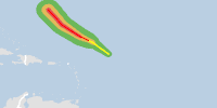
From 24/09/2025 to 24/09/2025, a Tropical Storm (maximum wind speed of 176 km/h) HUMBERTO-25 was active in Atlantic. The cyclone affects these countries: [unknown] (vulnerability [unknown]). Estimated population affected by category 1 (120 km/h) wind speeds or higher is 0 (0 in tropical storm).

Click this link to continue reading the article on the source website.
RSS feed source: Volcano Discovery.com--Global earthquake monitor

Wed, 24 Sep 2025, 20:49 | BY: EARTHQUAKEMONITOR

An earthquake of magnitude 4.0 occurred only 9 minutes ago 62 miles west of Hobart, Tasmania, Australia, the European-Mediterranean Seismological Centre (EMSC) reported.
The quake hit at a shallow depth of 6.2 miles beneath the epicenter near Hobart, Tasmania, Australia, early morning on Thursday, September 25th, 2025, at 6:38 am local time. The exact magnitude, epicenter, and depth of the quake might be revised within the next few hours or minutes as seismologists review data and refine their calculations, or as other agencies issue their report.
Our monitoring service identified a second report from the citizen-seismograph network of RaspberryShake which listed the quake at magnitude 4.0 as well.
Towns or cities near the epicenter where the quake might have been felt as very weak shaking include National Park (pop. 72) located 33 miles from the epicenter, Geeveston (pop. 1,300) 47 miles away, New Norfolk (pop. 5,400) 48 miles away, Ranelagh (pop. 1,200) 48 miles away, Franklin (pop. 1,100) 49 miles away, Huonville (pop. 2,700) 49 miles away, Margate (pop. 3,800) 60 miles away, and Hobart (pop. 247,100) 62 miles away.

If you felt it, report it through our site or app right now!

Download and Upgrade the Volcanoes & Earthquakes app to get one of the fastest seismic alerts online:
Android | IOS
Earthquake data:

I felt this quake

Date & time: Sep

Click this link to continue reading the article on the source website.