RSS feed source: Volcano Discovery.com--Global earthquake monitor

Date and TimeMag
DepthDistanceLocationDetailsMap Aug 31, 12:10 pm (Salta)

4.4

182 km86 km (53 mi) to the S Departamento de Los Andes, 164 km west of Salta, Departamento Capital, Salta Province, ArgentinaI FELT IT InfoAug 31, 09:30 am (GMT -4)

3.5

292 km60 km (37 mi) to the SW Provincia de El Loa, 284 km east of Antofagasta, Provincia de Antofagasta, Region de Antofagasta, ChileI FELT IT

Info

Aug 30, 09:54 pm (GMT -3)

3.4

246 km46 km (29 mi) to the NE Departamento de Susques, 205 km northwest of San Salvador de Jujuy, Departamento de Doctor Manuel Belgrano, Jujuy Province, ArgentinaI FELT IT

Info

Aug 30, 03:13 pm (GMT -4)

3.0

213 km55 km (34 mi) to the SW Provincia de El Loa, 298 km east of Antofagasta, Provincia de Antofagasta, Region de Antofagasta, ChileI FELT IT

Info

Aug 29, 08:39 pm (GMT -3)

3.6

229 km87 km (54 mi) to the NE Departamento de Susques, 172 km northwest of San Salvador de Jujuy, Departamento de Doctor Manuel Belgrano, Jujuy Province, ArgentinaI FELT IT

Info

Aug 26, 11:26 am (Salta)

4.3

163 km59 km (37 mi) to the S Departamento de Los Andes, 190 km northwest of Salta, Departamento Capital, Salta Province, ArgentinaI FELT IT InfoAug 22, 03:10 am (Jujuy)

4.5

190 km84 km (52 mi) to the SE Departamento de Susques, Jujuy Province, 35 km northwest of San Antonio de los Cobres, Departamento de Los Andes, Salta Province, Argentina InfoAug 16, 07:47 am (Santiago)

3.9

279 km48 km (30 mi) to the N 177 km southeast of Calama, Provincia

Click this link to continue reading the article on the source website.

RSS feed source: Volcano Discovery.com--Global earthquake monitor

Sun, 31 Aug 2025, 19:50 | BY: EARTHQUAKEMONITOR

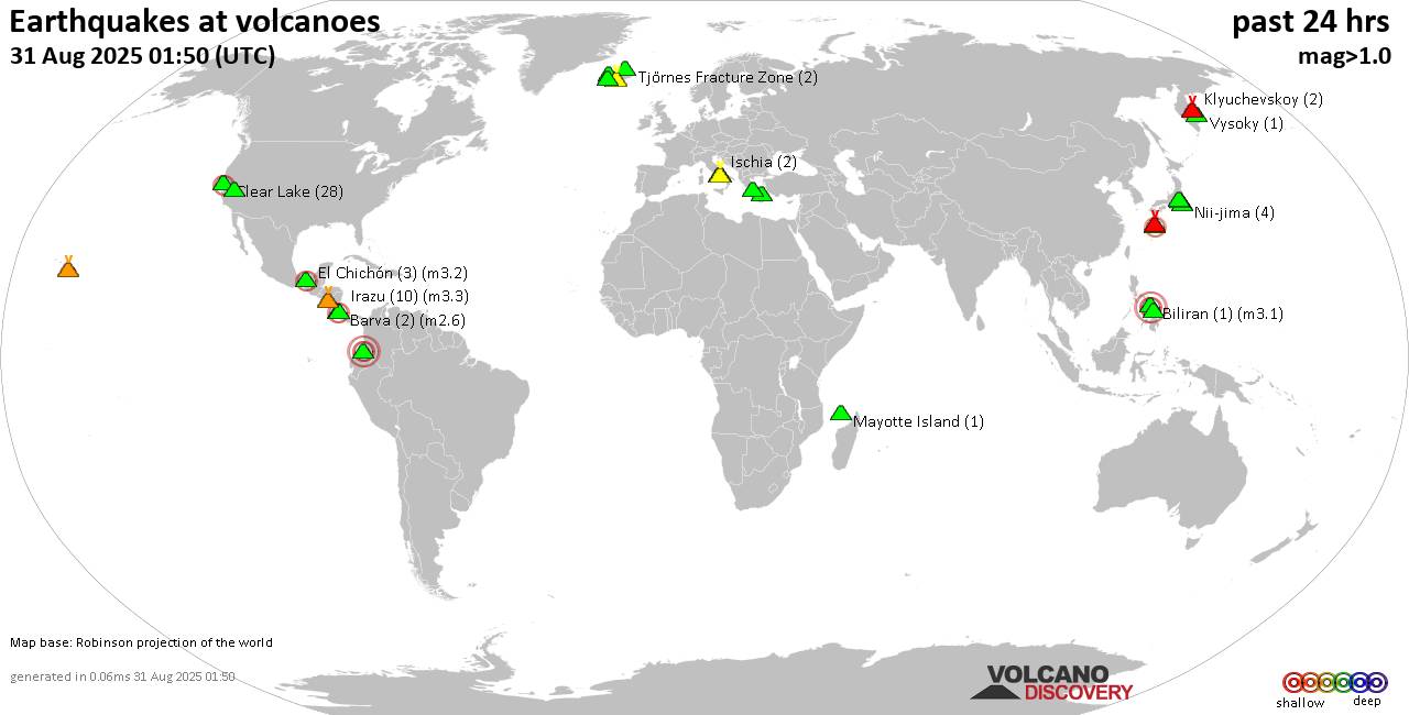
World map showing volcanoes with shallow (less than 50 km) earthquakes within 20 km radius during the past 24 hours on 31 Aug 2025 Number in brackets indicate nr of quakes.

Quakes detected near: Akuseki-jima (3 quakes between mag 2.4-2.8), Askja (1 quake mag 1.5), Bardarbunga (3 quakes between mag 0.1-1.4), Campi Flegrei (Phlegrean Fields) (34 quakes between mag 0.1-3.3), Clear Lake (23 quakes between mag 0.2-1.8), Coso (5 quakes between mag 0.2-1.8)
El Chichón (5 quakes between mag 2.3-3.0), Eldey (51 quakes between mag 0.2-3.3), Galeras (2 quakes between mag 1.1-3.6), Hofsjökull (8 quakes between mag 0.5-2.8), Hrómundartindur (2 quakes between mag 0.5-1.6), Ischia (2 quakes between mag 1.3-1.4), Katla (16 quakes between mag 0.3-2.1), Kilauea (1 quake mag 1.8), Kolumbo (2 quakes between mag 1.7-2.0), Krafla (2 quakes between mag 0.2-1.0), Krísuvík (24 quakes between mag 0.0-1.7), Kverkfjöll (1 quake mag 1.2), Ljósufjöll (3 quakes between mag 0.8-1.5), Mayotte Island (1 quake mag 1.4), Michoacán-Guanajuato (4 quakes between mag 1.7-2.5), Miyake-shima (1 quake mag 1.7), Mt Fuji (1 quake mag 1.1), Nemrut Dagi (2 quakes between mag 1.1-1.4), Nii-jima (5 quakes between mag 1.0-1.5), Pico de Orizaba (1 quake mag 2.8), Santorini (2 quakes between mag 0.8-1.1), Sousaki (1 quake mag 2.4), Suwanose-jima (2 quakes between mag 2.1-2.3), Svartsengi (4 quakes between mag 0.1-2.5),

Click this link to continue reading the article on the source website.
RSS feed source: Volcano Discovery.com--Global earthquake monitor

Sun, 31 Aug 2025, 19:28 | BY: EARTHQUAKEMONITOR

A moderately shallow magnitude 6.0 earthquake was reported late at night near Asadabad, Asadabad District, Kunar, Afghanistan.
According to the European-Mediterranean Seismological Centre (EMSC), the quake hit on Sunday, August 31st, 2025, at 11:17 pm local time at a moderately shallow depth of 35. km. The exact magnitude, epicenter, and depth of the quake might be revised within the next few hours or minutes as seismologists review data and refine their calculations, or as other agencies issue their report.
Our monitoring service identified a second report from the citizen-seismograph network of RaspberryShake which listed the quake at magnitude 6.2. Other agencies reporting the same quake include France’s Réseau National de Surveillance Sismique (RéNaSS) at magnitude 5.9, and the German Research Centre for Geosciences (GFZ) at magnitude 6.0.
Generally quakes of this magnitude are recorded by more than one agency and the results can vary, with subsequent reports that come in after the first one often showing more accuracy.
Based on the preliminary seismic data, the quake should have been widely felt by almost everyone in the area of the epicenter. It might have caused light to moderate damage.
Moderate shaking probably occurred in Asadabad (pop. 48,400) located 25 km from the epicenter.
In Shabqadar (pop. 66,500) located 87 km from the epicenter, Tangi (pop. 29,400) 88 km away, Bat

Click this link to continue reading the article on the source website.

RSS feed source: Volcano Discovery.com--Global earthquake monitor

Date and TimeMag
DepthDistanceLocationDetailsMap Aug 13, 04:20 pm (GMT +7)

4.3

10 km100 km (62 mi) to the E Indian Ocean, 42 km north of Pulau Enggano Island, Bengkulu, Indonesia InfoJun 17, 09:06 pm (GMT +7)

4.6

21 km80 km (50 mi) to the E Indian Ocean, 84 km south of Bengkulu, Kota Bengkulu, Bengkulu, Indonesia InfoJun 16, 02:44 am (GMT +7)

4.3

10 km40 km (25 mi) to the NE Southern Sumatra, Indonesia InfoMay 23, 02:52 am (GMT +7)

6.0

84 km91 km (56 mi) to the NE Indian Ocean, 48 km southwest of Bengkulu, Kota Bengkulu, Bengkulu, Indonesia 8 reportsInfoFeb 19, 11:26 pm (GMT +7)

4.3

14 km59 km (37 mi) to the SE Southern Sumatra, Indonesia InfoNov 18, 2022 08:37 pm (GMT +7)

6.8

10 km90 km (56 mi) to the W Indian Ocean, 216 km southwest of Bengkulu, Kota Bengkulu, Bengkulu, Indonesia 2 reportsInfoAug 19, 2020 05:29 am (GMT +7)

6.9

40 km66 km (41 mi) to the N Indian Ocean, 109 km west of Bengkulu, Kota Bengkulu, Bengkulu, Indonesia 19 reportsInfoAug 19, 2020 05:24 am (GMT +7)

6.7

39 km60 km (37 mi) to the N Southern Sumatra, Indonesia 13 reportsInfoOct 25, 2010 09:42 pm (GMT +7)

7.7

10 km200 km (125 mi) to the NW Indian Ocean, 54 km southwest of Pulau Taitaitanopo Island, Indonesia InfoMay 5, 2010 11:29 pm (Jakarta)

6.5

27 km81 km (51 mi) to the NW 132 km WSW of Bengkulu, Indonesia InfoNov 22, 2008 11:01 pm (GMT +7)

6.3

24 km44 km (27 mi) to the NW southern Sumatra, Indonesia InfoFeb 25, 2008 03:36 pm (Jakarta)

7.2

25 km295 km (183 mi) to the NW 164 km WSW of Sungai Penuh, Indonesia

Click this link to continue reading the article on the source website.