RSS feed source: Volcano Discovery.com--Global earthquake monitor

Date and TimeMag
DepthDistanceLocationDetailsMap Dec 23, 2020 05:29 pm (GMT +11)

4.3

33 km59 km (37 mi) to the N Tasman Sea, 375 km west of Invercargill, Southland, New Zealand InfoDec 22, 2020 09:58 pm (GMT +11)

4.1

33 km84 km (52 mi) to the N Tasman Sea, 401 km west of Invercargill, Southland, New Zealand 1 reportInfoFeb 15, 2016 07:28 pm (Universal Time)

5.4

10 km92 km (57 mi) to the Snear Magnitude 5.4, Near of Christchurch 1 reportInfoDec 2, 2012 11:51 pm (GMT +11)

4.1

12 km91 km (57 mi) to the E Off W. Coast of S. Island, N.Z. InfoAug 7, 2010 02:57 pm (GMT +11)

4.3

10 km99 km (61 mi) to the S Tasman Sea, 431 km southwest of Tuatapere, Southland, New Zealand InfoDec 30, 2007 05:52 pm (Universal Time)

4.1

35 km72 km (45 mi) to the SE Off The West Coast of The South Island of New Zealand InfoOct 4, 2007 10:22 pm (Universal Time)

3.9

0 km30 km (19 mi) to the NW Off W. Coast of S. Island, N.Z.

Info

Sep 30, 2007 06:23 am (Universal Time)

3.9

0 km80 km (50 mi) to the SE Off W. Coast of S. Island, N.Z.

Info

Sep 30, 2007 04:29 pm (GMT +11)

4.5

0 km93 km (58 mi) to the SE Off W. Coast of S. Island, N.Z. InfoSep 30, 2007 04:23 pm (GMT +11)

7.4

10 km166 km (103 mi) to the S Tasman Sea, 216 km northwest of Auckland Island, New Zealand InfoMar 10, 2005 09:46 am (GMT +11)

4.2

0 km70 km (43 mi) to the SE Off W. Coast of S. Island, N.Z. InfoJan 11, 2005 10:49 pm

Click this link to continue reading the article on the source website.

RSS feed source: Volcano Discovery.com--Global earthquake monitor

Sun, 9 Nov 2025, 17:52 | BY: EARTHQUAKEMONITOR

A magnitude 3.7 earthquake near San Ramon, Contra Costa County, California, USA, was reported only 12 minutes ago by the United States Geological Survey, considered the key international and national agency that monitors seismic activity in the US. The earthquake occurred at a very shallow depth of 5.8 miles beneath the epicenter in the morning on Sunday, November 9th, 2025, at 9:38 am local time. The exact magnitude, epicenter, and depth of the quake might be revised within the next few hours or minutes as seismologists review data and refine their calculations, or as other agencies issue their report.
Our monitoring service identified a second report from The Incorporated Research Institutions for Seismology (IRIS) which listed the quake at magnitude 3.7 as well. A third agency, the European-Mediterranean Seismological Centre (EMSC), reported the same quake at magnitude 3.7.
Based on the preliminary seismic data, the quake should not have caused any significant damage, but was probably felt by many people as light vibration in the area of the epicenter.
Weak shaking might have been felt in San Ramon (pop. 76,100) located 2 miles from the epicenter, Dublin (pop. 57,700) 4 miles away, Danville (pop. 44,400) 5 miles away, Pleasanton (pop. 79,500) 8 miles away, Hayward (pop. 158,300) 10 miles away, Livermore (pop. 88,100) 11 miles away,

Click this link to continue reading the article on the source website.
RSS feed source: Volcano Discovery.com--Global earthquake monitor

Sun, 9 Nov 2025, 17:50 | BY: EARTHQUAKEMONITOR

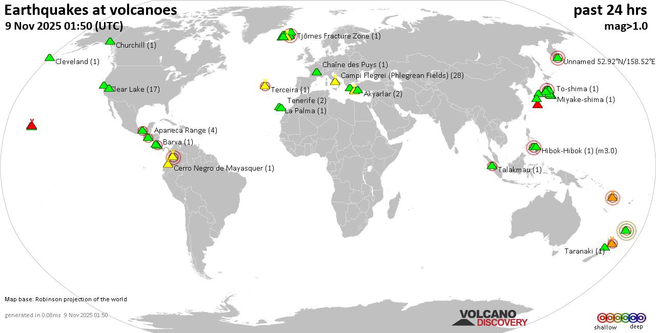
World map showing volcanoes with shallow (less than 50 km) earthquakes within 20 km radius during the past 24 hours on 9 Nov 2025 Number in brackets indicate nr of quakes.

Quakes detected near: Akagi (1 quake mag 1.1), Akuseki-jima (1 quake mag 2.3), Aoba (1 quake mag 3.6), Apaneca Range (1 quake mag 2.0), Askja (3 quakes between mag 0.4-3.5), Aso (1 quake mag 1.0)
Barva (1 quake mag 1.5), Batu Tara (1 quake mag 3.4), Campi Flegrei (Phlegrean Fields) (47 quakes between mag 0.1-2.5), Canlaon (3 quakes between mag 2.4-2.9), Cerro Negro de Mayasquer (2 quakes between mag 3.2-3.5), Chaîne des Puys (1 quake mag 1.9), Chiginagak (2 quakes between mag 2.1-2.3), Ciremai (1 quake mag 2.5), Clear Lake (14 quakes between mag 0.4-2.1), Cuernos de Negros (1 quake mag 3.0), El Chichón (7 quakes between mag 2.2-2.8), Eldey (2 quakes between mag 1.3-1.7), Eyafjallajökull (1 quake mag 1.1), Grímsnes (4 quakes between mag 0.6-1.9), Havre Seamount (1 quake mag 4.0), Hekla (3 quakes between mag 0.8-2.3), Kilauea (3 quakes between mag 1.8-1.9), Kolumbo (2 quakes between mag 1.2-1.2), Krísuvík (5 quakes between mag 0.6-1.4), Kurikoma (1 quake mag 1.0), La Palma (1 quake mag 1.2), Lavic Lake (1 quake mag 1.0), Ljósufjöll (2 quakes between mag 1.1-1.2), Loihi (1 quake mag 1.8), Masaya

Click this link to continue reading the article on the source website.

RSS feed source: Volcano Discovery.com--Global earthquake monitor

Sun, 9 Nov 2025, 17:49 | BY: EARTHQUAKEMONITOR

An earthquake of magnitude 3.6 occurred in the morning on Sunday, November 9th, 2025, at 9:39 am local time near San Ramon, Contra Costa County, California, USA, as reported by the United States Geological Survey.
According to preliminary data, the quake was located at a very shallow depth of 5.4 miles. Shallow earthquakes are felt more strongly than deeper ones as they are closer to the surface. The exact magnitude, epicenter, and depth of the quake might be revised within the next few hours or minutes as seismologists review data and refine their calculations, or as other agencies issue their report.
A second report was later issued by The Incorporated Research Institutions for Seismology (IRIS), which listed it as a magnitude 3.7 earthquake. A third agency, the European-Mediterranean Seismological Centre (EMSC), reported the same quake at magnitude 3.6.
Based on the preliminary seismic data, the quake should not have caused any significant damage, but was probably felt by many people as light vibration in the area of the epicenter.
Weak shaking might have been felt in San Ramon (pop. 76,100) located 3 miles from the epicenter, Dublin (pop. 57,700) 4 miles away, Danville (pop. 44,400) 5 miles away, Pleasanton (pop. 79,500) 8 miles away, Hayward (pop. 158,300) 10 miles away, and Livermore (pop. 88,100) 11 miles away.
Other

Click this link to continue reading the article on the source website.