RSS feed source: Volcano Discovery.com

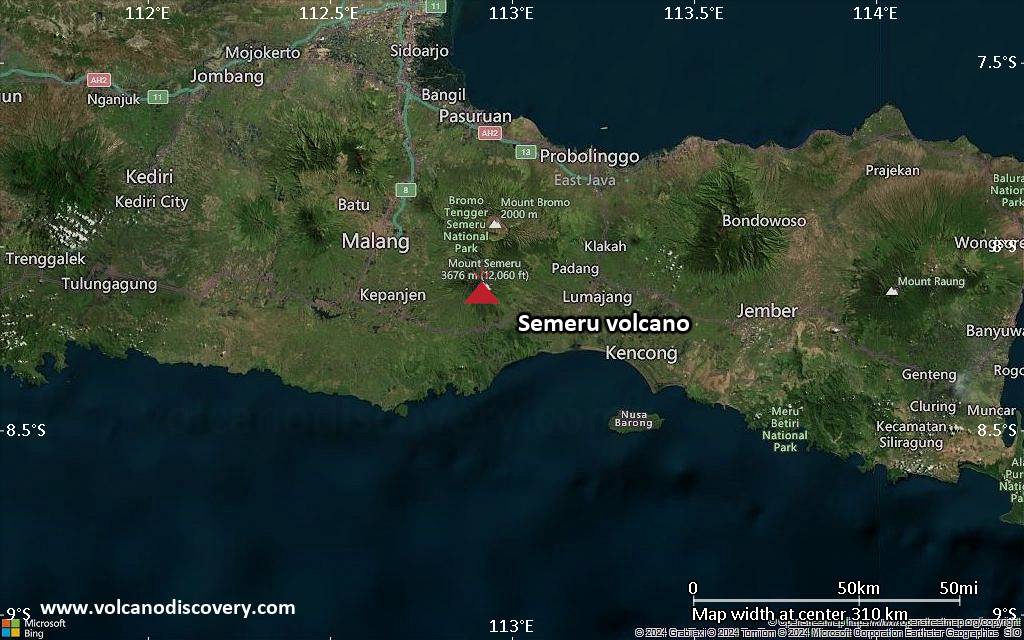
<!–div style="font-size:14px;text-align:center;border:3px solid blue;border-radius:5px;padding:3px;margin:5px;background:#eee"><a href="https://www.volcanoesandearthquakes.com/app/volcano-report.php?volcanoId=44" style="text-decoration:none" target="_blank" rel="noopener noreferrer nofollow" title="Share a volcano (activity) report, submit a photo or other interesting news!” onclick=”window.open(this.href,’Volcano Report’,’status=0,toolbar=0,location=0,directories=0,menubar=0,resizable=1,scrollbars=1,height=500,width=450′);return false”>Send Volcano Report</div–> Stratovolcano 3676 m (12,060 ft)
East Java, Indonesia, -8.11°S / 112.92°E
Current status: erupting (4 out of 5) Semeru volcano eruptions:
1818, 1829, 1830, 1832, 1836, 1838, 1842, 1844, 1845, 1848, 1849(?), 1851, 1856, 1857, 1865, 1866(?), 1887, 1887, 1888, 1889-91, 1892, 1893, 1893-94, 1895, 1896, 1897, 1899, 1899, 1900, 1901, 1903, 1904, 1905, 1907, 1908, 1909-10, 1910-11, 1911, 1912, 1913, 1941-42, 1945, 1946, 1946-47, 1950-64, 1967-ongoing
Typical eruption style
Explosive. Near constant strombolian activity, occasionally stronger explosions, lava flows and pyroclastic flows.

Click this link to continue reading the article on the source website.
RSS feed source: Volcano Discovery.com

Tue, 13 May 2025, 22:58 | BY: EARTHQUAKEMONITOR

Just 6 minutes ago, a 6.1-magnitude earthquake struck near Ierapetra, Lasithi, Crete, Greece. The tremor was recorded early morning on Wednesday, May 14th, 2025, at 1:51 am local time, at a moderately shallow depth of 39. km below the surface.
The event was filed by the National Observatory of Athens (NOA), the first seismological agency to report it.
A second report was later issued by the citizen-seismograph network of RaspberryShake, which listed it as a magnitude 6.1 earthquake as well. Other agencies reporting the same quake include the European-Mediterranean Seismological Centre (EMSC) at magnitude 6.2, The Seismological Survey of Serbia (SSS) at magnitude 6.4, the German Research Centre for Geosciences (GFZ) at magnitude 6.1, The Seismological Laboratory of the University of Athens (UOA) at magnitude 5.9, and The Aristotle University of Thessaloniki Geophysical Lab. (AUTH) at magnitude 6.0.
Generally quakes of this magnitude are recorded by more than one agency and the results can vary, with subsequent reports that come in after the first one often showing more accuracy.
Based on the preliminary seismic data, the quake was probably felt by many people in the area of the epicenter. It should not have caused significant damage, other than objects falling from shelves, broken windows, etc.
In Ierapetra (pop. 12,400) located 114 km from the epicenter, the quake should

Click this link to continue reading the article on the source website.

RSS feed source: Volcano Discovery.com

Date and TimeMag
DepthDistanceLocationDetailsMap Feb 2, 07:29 pm (Tirane)

4.3

10 km80 km (50 mi) to the N 21 km southeast of Vlore, Qarku i Vlores, Albania 2 reportsInfoDec 22, 2024 03:33 pm (Athens)

4.0

10 km36 km (22 mi) to the E Nomos Thesprotias, 39 km west of Ioannina, Ioannina, Epirus, Greece 3 reportsInfoOct 1, 2024 06:14 am (Tirane)

4.0

10 km26 km (16 mi) to the E 8 km NE of Konispol, Albania 32 reportsInfoJul 12, 2024 09:48 am (Athens)

4.0

16 km89 km (55 mi) to the SE Nomos Prevezis, 41 km south of Ioannina, Ioannina, Epirus, Greece 17 reportsInfoMar 22, 2024 06:20 am (GMT +1)

4.6

10 km66 km (41 mi) to the W Ionian Sea, 60 km west of Corfu, Nomos Kerkyras, Ionian Islands, Greece 47 reportsInfoJan 6, 2024 12:51 am (Athens)

4.2

47 km44 km (28 mi) to the E 6 Km N From Leptokaria 48 reportsInfoSep 2, 2023 08:17 am (Tirane)

4.5

10 km80 km (50 mi) to the NE 10 km NNW of Leskovik, Albania 1 reportInfoAug 4, 2023 10:19 pm (Tirane)

4.1

19 km48 km (30 mi) to the N 15 km west of Gjirokaster, Qarku i Gjirokastres, Albania 15 reportsInfoMar 21, 2020 02:49 am (Athens)

5.7

7 km68 km (42 mi) to the SE 10.4 km northeast of Mesopotamo, Nomos Prevezis, Epirus, Greece 486 reportsInfoFeb 5, 2019 04:26 am (Athens)

5.4

10 km88 km (55 mi) to the SE Ionian Sea, 18 km northwest of Preveza, Nomos Prevezis, Epirus, Greece 67 reportsInfoOct 16, 2016 03:41 am (Athens)

4.9

15 km59 km (36 mi) to the E Greece-Albania Border Region 4 reportsInfoOct 15, 2016 11:14 pm (Athens)

5.3

23 km60 km (38 mi) to

Click this link to continue reading the article on the source website.

RSS feed source: Volcano Discovery.com

Date and TimeMag
DepthDistanceLocationDetailsMap May 10, 07:55 am (Nicosia)

3.3

33 km70 km (43 mi) to the E 13 km southwest of Nicosia, Nicosia, CyprusI FELT IT3 reportsInfoApr 8, 12:23 pm (Nicosia)

3.1

7 km71 km (44 mi) to the E Larnaka, 45 km south of Nicosia, Nicosia, Cyprus

Info

Apr 1, 06:17 am (Nicosia)

3.1

10 km18 km (11 mi) to the SE 62 km E of Egegik, Alaska 30 reportsInfoMar 24, 08:04 am (GMT +2)

3.2

37 km43 km (27 mi) to the E Cyprus Region 44 reportsInfoMar 2, 01:07 pm (GMT +2)

3.0

37 km44 km (27 mi) to the E Cyprus Region 29 reportsInfoDec 24, 2024 08:22 pm (GMT +2)

4.4

10 km52 km (32 mi) to the W Eastern Mediterranean, 38 km west of Paphos, Pafos, Cyprus 38 reportsInfoDec 3, 2024 12:23 am (Nicosia)

4.2

10 km74 km (46 mi) to the SE Eastern Mediterranean, 25 km southeast of Limassol, Limassol District, Cyprus 217 reportsInfoNov 16, 2024 10:46 am (Nicosia)

3.9

34 km29 km (18 mi) to the SW Eastern Mediterranean, 14 km south of Paphos, Pafos, Cyprus 61 reportsInfoSep 29, 2024 02:18 am (Nicosia)

4.0

10 km31 km (19 mi) to the SEastern Mediterranean, 63 km southwest of Cyprus Island, Cyprus 125 reportsInfoSep 4, 2024 12:29 am (Nicosia)

4.9

17 km37 km (23 mi) to the SW Eastern Mediterranean, 19 km southwest of Paphos, Pafos, Cyprus 1318 reportsInfoAug 30, 2022 10:42 pm (GMT +2)

4.5

10 km59 km (37 mi) to the NW Eastern Mediterranean, 55 km northwest of Paphos, Paphos, Cyprus 29 reportsInfoApr 26, 2022 10:11 pm (Nicosia)

4.9

10 km19 km (12 mi) to the SW 3.2 km south of Paphos, Pafos, Cyprus

Click this link to continue reading the article on the source website.