RSS feed source: Volcano Discovery.com--Global earthquake monitor

Date and TimeMag
DepthDistanceLocationDetailsMap Aug 14, 04:22 pm (GMT -6)

4.0

18 km74 km (46 mi) to the SE North Pacific Ocean, 146 km southeast of Salina Cruz, Estado de Oaxaca, MexicoI FELT IT InfoAug 12, 04:07 pm (GMT -6)

4.0

16 km98 km (61 mi) to the SE North Pacific Ocean, 169 km southeast of Salina Cruz, Estado de Oaxaca, MexicoI FELT IT InfoAug 11, 07:58 am (GMT -6)

4.3

45 km44 km (28 mi) to the NE North Pacific Ocean, 70 km southeast of Salina Cruz, Estado de Oaxaca, MexicoI FELT IT InfoAug 11, 03:52 am (GMT -6)

4.3

3.4 km94 km (58 mi) to the SE North Pacific Ocean, 165 km southeast of Salina Cruz, Estado de Oaxaca, MexicoI FELT IT InfoAug 11, 02:38 am (GMT -6)

4.0

20 km90 km (56 mi) to the SE North Pacific Ocean, 149 km southeast of Salina Cruz, Estado de Oaxaca, MexicoI FELT IT InfoAug 10, 10:46 pm (GMT -6)

4.1

18 km100 km (62 mi) to the SE North Pacific Ocean, 171 km southeast of Salina Cruz, Estado de Oaxaca, MexicoI FELT IT2 reportsInfoAug 10, 08:32 pm (GMT -6)

4.1

13 km99 km (62 mi) to the SE North Pacific Ocean, 172 km southeast of Salina Cruz, Estado de Oaxaca, MexicoI FELT IT InfoAug 5, 01:12 am (GMT -6)

4.2

16 km32 km (20 mi) to the SE North Pacific Ocean, 99 km southeast of Salina Cruz, Estado de Oaxaca, Mexico InfoMar 5, 03:43 am (GMT -6)

5.5

47 km38 km (23 mi) to the NE North Pacific

Click this link to continue reading the article on the source website.

RSS feed source: Volcano Discovery.com--Global earthquake monitor

Support Us – Help Us Enhance Our Services! We’re passionate about delivering the latest volcano and earthquake data from around the globe — just for you. However, maintaining our website and free apps requires significant time, effort, and resources.
Your support helps us expand our hardware and software capabilities and empowers our dedicated editorial team. Our mission is to provide uninterrupted, real-time updates whenever an earthquake strikes or a volcano erupts — and your donations make this possible. Every contribution, big or small, is deeply appreciated. If you find our information valuable and want to help us add new features, create compelling content, and improve our technology, please consider making a donation: Donate with Card or Apple/Google Pay: Donate with PayPal: Planned Features: Improved multilingual support Tsunami alerts Faster responsiveness Thanks to your past donations, we have recently

Click this link to continue reading the article on the source website.

RSS feed source: Volcano Discovery.com--Global earthquake monitor

Very strong magnitude 6.0 earthquake at unknown depth

15 Aug 10:18 UTC: First to report: VolcanoDiscovery after 7 minutes.
15 Aug 10:21: Now using data updates from GFZ
15 Aug 10:21: Magnitude recalculated from 5.9 to 6.0.

I didn’t feel it

I felt this quake

Earthquake details Date & timeAug 15, 2025 10:11:48 UTC – Local time at epicenterFriday, Aug 15, 2025, at 10:11 am (Universal Time GMT +0) Statusunconfirmed (uncertain whether an earthquake with these data happened) Magnitude6.0 Depth10 km Epicenter latitude / longitude52.73°N / 159.93°E Kamchatka, Russia Seismic antipode52.73°S / 20.07°W Shaking intensityVI Strong shaking near epicenter Felt2 reports Primary data sourceGFZ (German Research Centre for Geosciences) Nearest volcanoAvachinsky (94 km / 58 mi) Weather at epicenter at time of quakeOvercast Clouds 15.1°C (59 F), humidity: 88%, wind: 2 m/s (4 kts) from S Estimated seismic energy released6.3 x 1013 joules (17.5 gigawatt hours, equivalent to 15080 tons of TNT or 0.9 atomic bombs!) | equivalent to ONE quake of magnitude 6.0 | about seismic energy

[smaller] [bigger]

Nearby places The closest larger town where the quake might have been felt is Petropavlovsk-Kamchatskiy, a city with more than 180,000 inhabitants in Russia, in 95 km (59 mi) distance northwest of the epicenter. People likely experienced light shaking there.
The following

Click this link to continue reading the article on the source website.
RSS feed source: Volcano Discovery.com--Global earthquake monitor

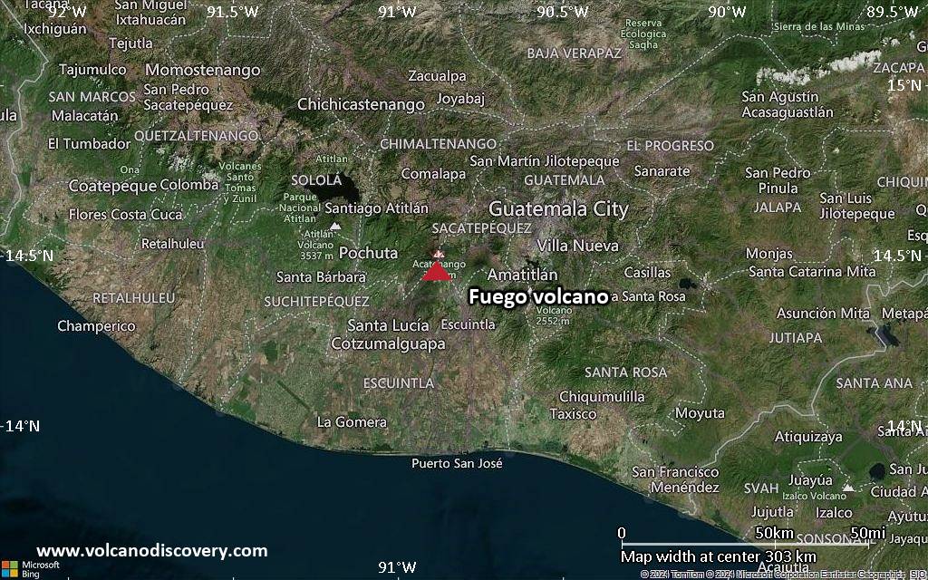
<!–div style="font-size:14px;text-align:center;border:3px solid blue;border-radius:5px;padding:3px;margin:5px;background:#eee"><a href="https://www.volcanoesandearthquakes.com/app/volcano-report.php?volcanoId=26" style="text-decoration:none" target="_blank" rel="noopener noreferrer nofollow" title="Share a volcano (activity) report, submit a photo or other interesting news!” onclick=”window.open(this.href,’Volcano Report’,’status=0,toolbar=0,location=0,directories=0,menubar=0,resizable=1,scrollbars=1,height=500,width=450′);return false”>Send Volcano Report</div–> Stratovolcano 3,763 m / 12,346 ft
Guatemala, 14.47°N / -90.88°W
Current status: erupting (4 out of 5) Fuego volcano eruptions:
1581, 1585, 1586, 1587, 1614, 1617, 1620, 1623, 1629, 1679(?), 1685, 1686, 1689(?), 1699, 1702, 1705, 1706, 1709(?), 1710,1717,1730, 1732, 1737, 1751(?), 1765(?), 1773(?), 1799, 1826, 1829, 1850(?), 1852(?), 1855, 1856, 1857, 1860, 1861(?), 1867(?), 1880, 1896, 1932, 1944, 1949, 1953, 1955, 1957, 1962, 1963, 1966, 1967, 1971, 1973, 1974, 1975, 1977, 1987, 1999, 2002 – ongoing
Typical eruption style
Dominantly explosive, construction of lava domes and extrusion of viscous lava flows. In near constant activity, at least during the past centuries.

Click this link to continue reading the article on the source website.