RSS feed source: USGS Earthquake Hazards Program
Time2025-12-04 13:34:42 UTC2025-12-04 13:34:42 UTC at epicenterLocation0.755°N 123.863°EDepth251.67 km (156.38 mi)
Click this link to continue reading the article on the source website.
RSS feed source: USGS Earthquake Hazards Program
Time2025-12-04 13:34:42 UTC2025-12-04 13:34:42 UTC at epicenterLocation0.755°N 123.863°EDepth251.67 km (156.38 mi)
Click this link to continue reading the article on the source website.
RSS feed source: USGS Earthquake Hazards Program
Date and TimeMag
DepthDistanceLocationDetailsMap Dec 4, 06:52 pm (Urumqi)
4.6
0 km27 km (17 mi) to the NW 156 km west of Aqsu, Xinjiang, China I FELT IT InfoDec 4, 05:05 pm (Urumqi)
4.6
0 km16 km (10 mi) to the W 146 km north of Tumxuk, Xinjiang, China I FELT IT – 7 reportsInfoDec 4, 02:42 pm (Urumqi)
4.3
0 km33 km (20 mi) to the W 159 km northwest of Tumxuk, Xinjiang, China I FELT IT InfoDec 4, 03:44 pm (Urumqi)
5.8
10 km23 km (14 mi) to the W 138 km NNW of Tumxuk, China I FELT IT – 163 reportsInfoNov 24, 08:44 am (Urumqi)
4.5
33 km27 km (17 mi) to the N 132 km west of Aqsu, Xinjiang, China 1 reportInfoOct 2, 04:00 pm (Urumqi)
4.4
5 km50 km (31 mi) to the W 150 km northwest of Tumxuk, Xinjiang, China 1 reportInfoFeb 25, 2024 10:15 am (Urumqi)
5.4
10 km26 km (16 mi) to the NW 155 km west of Aqsu, Xinjiang, China 153 reportsInfoJan 30, 2024 04:27 am (Urumqi)
5.7
10 km13 km (7.9 mi) to the NW 137 km west of Aqsu, Xinjiang, China 69 reportsInfoJan 26, 2024 02:01 am (Urumqi)
5.3
10 km23 km (14 mi) to the NE 119 km west of Aqsu, Xinjiang, China 211 reportsInfoJan 24, 2024 02:38 am (Urumqi)
5.2
10 km10.2 km (6.3 mi) to the W 141 km west of Aqsu, Xinjiang, China 27 reportsInfoJan 23, 2024 07:18 am (Urumqi)
5.3
3.4 km16 km (10 mi) to the N 127 km west of Aqsu, Xinjiang, China 6 reportsInfoJan 23, 2024 01:36 am (Urumqi)
5.5
10 km14 km (8.4 mi) to the NW 137 km west of Aqsu, Xinjiang,
Click this link to continue reading the article on the source website.
RSS feed source: USGS Earthquake Hazards Program
Support Us – Help Us Enhance Our Services! We’re passionate about delivering the latest volcano and earthquake data from around the globe — just for you. However, maintaining our website and free apps requires significant time, effort, and resources.
Your support helps us expand our hardware and software capabilities and empowers our dedicated editorial team. Our mission is to provide uninterrupted, real-time updates whenever an earthquake strikes or a volcano erupts — and your donations make this possible. Every contribution, big or small, is deeply appreciated. If you find our information valuable and want to help us add new features, create compelling content, and improve our technology, please consider making a donation: Donate with PayPal: Planned Features: Improved multilingual support Tsunami alerts Faster responsiveness Thanks to your past donations, we have recently added: Design upgrades Detailed earthquake
Click this link to continue reading the article on the source website.
RSS feed source: USGS Earthquake Hazards Program
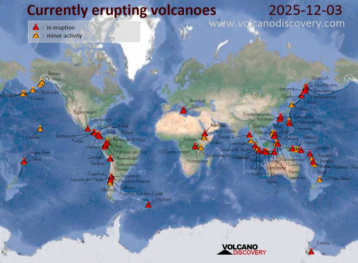
Thursday, Dec 4, 2025 06:00 | By: VN
Sakurajima (Kyushu, Japan): Explosive activity continues. Volcanic Ash Advisory Center (VAAC) Tokyo warned about a volcanic ash plume that rose up to estimated 6000 ft (1800 m) altitude or flight level 060 .
The full report is as follows: ERUPTED AT 20251203/2342Z FL060 EXTD SE OBS VA DTG:04/0010Z to 6000 ft (1800 m)
Ibu (Halmahera, Indonesia): Volcanic Ash Advisory Center Darwin (VAAC) issued the following report: VA REPORTED TO FL070 MOV NE AT 04/0240Z EST VA DTG:04/0330Z
Semeru (East Java, Indonesia): Volcanic Ash Advisory Center Darwin (VAAC) issued the following report: VA ERUPTION LAST REPORTED AT 03/1829Z EST VA DTG:03/2150Z
Aoba (Vanuatu): Explosive activity continues. Volcanic Ash Advisory Center (VAAC) Wellington warned about a volcanic ash plume that rose up to estimated 8000 ft (2400 m) altitude or flight level 080 and is moving at 10 kts in NW direction.
The
Click this link to continue reading the article on the source website.