RSS feed source: US National Weather Service

* WHAT…1 1/2 to 2 1/2 feet of inundation above ground level is expected in vulnerable areas near the waterfront and shoreline for this afternoon, but moreso tonight and Monday afternoon high tide cycles. * WHERE…Southern Westchester, Bronx, Northwest Suffolk, Northern Queens and Northern Nassau Counties. * WHEN…From 2 PM this afternoon to 8 PM EDT Monday, around the times of high tide. * COASTAL FLOOD IMPACTS…Moderate coastal flooding expected, with 1 1/2 to 2 1/2 ft of inundation above ground level in vulnerable areas near the waterfront and shoreline. This will result in several road closures and flooding of numerous low lying properties including parking lots, parks, lawns and homes/businesses

Click this link to continue reading the article on the source website.

RSS feed source: US National Weather Service

Date and TimeMag
DepthDistanceLocationDetailsMap Oct 8, 11:33 am (GMT +8)

4.4

19 km86 km (54 mi) to the SE Philippine Sea, 76 km southeast of Hualien City, TaiwanI FELT IT InfoOct 8, 07:52 am (Taipei)

5.1

10 km30 km (19 mi) to the SW 4 km south of Hualien City, TaiwanI FELT IT5 reportsInfoSep 22, 03:20 am (Taipei)

4.4

30 km98 km (61 mi) to the SW 15 km E of Lugu, Taiwan 1 reportInfoSep 21, 12:36 pm (Taipei)

4.5

26 km8.1 km (5 mi) to the E Philippine Sea, 32 km northeast of Hualien City, Taiwan InfoSep 19, 05:21 am (Taipei)

4.6

21 km25 km (15 mi) to the S 7 km ESE of Hualien City, Taiwan 1 reportInfoSep 13, 01:46 pm (GMT +9)

4.6

40 km82 km (51 mi) to the E 73 km SW of Yonakuni, Japan InfoSep 8, 02:50 pm (GMT +9)

4.8

10 km92 km (57 mi) to the SE 93 km SSW of Yonakuni, Japan InfoApr 3, 2024 08:11 am (Taipei)

6.4

14 km11 km (6.8 mi) to the SW Philippine Sea, 16 km northeast of Hualien City, Taiwan 32 reportsInfoApr 3, 2024 07:58 am (Taipei)

7.4

40 km41 km (25 mi) to the SW Philippine Sea, 16 km south of Hualien City, Taiwan 232 reportsInfoMar 23, 2022 01:41 am (Taipei)

6.7

24 km89 km (55 mi) to the S Philippine Sea, 66 km south of Hualien City, Taiwan 89 reportsInfoFeb 6, 2018 11:50 pm (Taipei)

6.4

17 km11 km (6.9 mi) to the W 18 km NNE of Hualien City, Taiwan 52 reportsInfoApr 20, 2015 10:42 am (GMT +9)

6.6

30 km69 km (43 mi) to the E Taiwan Region 35 reportsInfoDec

Click this link to continue reading the article on the source website.

RSS feed source: US National Weather Service

Date and TimeMag
DepthDistanceLocationDetailsMap Jul 30, 10:50 am (Makassar)

4.4

10 km26 km (16 mi) to the N Sulawesi, Indonesia InfoMay 27, 07:27 pm (Makassar)

4.6

10 km50 km (31 mi) to the SE Banda Sea, 27 km south of Pulau Witamemea Island, Southeast Sulawesi, Indonesia InfoSep 16, 2023 08:28 am (Makassar)

4.2

2 km80 km (50 mi) to the W Kabupaten Bombana, 89 km west of Katobu, Indonesia InfoAug 9, 2023 02:29 am (Makassar)

4.0

5 km96 km (60 mi) to the N Banda Sea, 10.5 km north of Kendari, Kota Kendari, Southeast Sulawesi, Indonesia 1 reportInfoApr 16, 2023 11:29 am (Makassar)

4.5

17 km95 km (59 mi) to the SW Banda Sea, 27 km west of Pulau Kadatuang Island, Southeast Sulawesi, Indonesia InfoMay 12, 2022 01:07 pm (Makassar)

4.2

54 km8.7 km (5.4 mi) to the N Kabupaten Muna Barat, 17 km north of Katobu, Indonesia InfoMay 22, 2014 10:40 am (Makassar)

4.8

12 km54 km (34 mi) to the N Kabupaten Konawe Selatan, 48 km southeast of Kendari, Indonesia InfoJan 24, 2013 05:35 pm (Makassar)

4.9

640 km65 km (40 mi) to the N Kabupaten Konawe Selatan, 45 km southeast of Kendari, Indonesia InfoJun 12, 2011 10:30 pm (Makassar)

4.7

12 km49 km (30 mi) to the NE Kabupaten Konawe Selatan, 56 km southeast of Kendari, Indonesia InfoApr 25, 2011 07:25 am (Makassar)

4.8

6 km69 km (43 mi) to the N Kabupaten Konawe Selatan, 21 km southeast of Kendari, Indonesia InfoApr 25, 2011 07:10 am (Makassar)

4.9

5.5 km55 km (34 mi) to the NE 55 km SE of Kendari, Indonesia InfoApr 25, 2011 07:07 am (Makassar)

6.1

8 km22 km (14 mi) to the NE 47 km NE

Click this link to continue reading the article on the source website.

RSS feed source: US National Weather Service

Sun, 12 Oct 2025, 14:20 | BY: EARTHQUAKEMONITOR

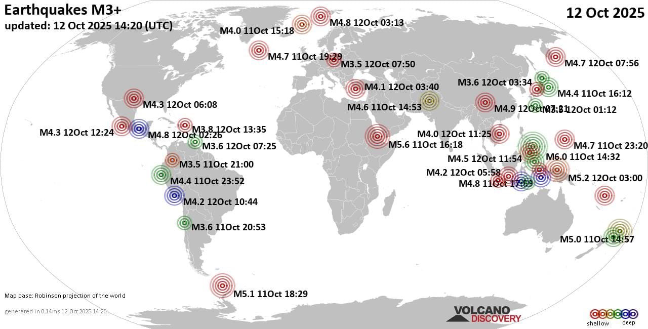
Worldwide earthquakes above magnitude 3 during the past 24 hours on 12 Oct 2025

Summary: 1 quake 6.0+, 6 quakes 5.0+, 48 quakes 4.0+, 153 quakes 3.0+, 347 quakes 2.0+ (555 total)
This report is being updated every hour.
Magnitude 6+: 1 earthquake
Magnitude 5+: 6 earthquakes
Magnitude 4+: 48 earthquakes
Magnitude 3+: 153 earthquakes
Magnitude 2+: 347 earthquakes
No quakes of magnitude 7 or higherTotal seismic energy estimate: 1.5 x 10¹⁴ joules (40.5 gigawatt hours, equivalent to 34822 tons of TNT or 2.2 atomic bombs!) | equivalent to ONE quake of magnitude 6.2 learn more10 largest earthquakes in the world (past 24 hours)#1: Mag 6.0 Philippine Sea, 28 km southeast of Tandag, PhilippinesSaturday, Oct 11, 2025, at 10:32 pm (Manila time) – #2: Mag 5.8 Philippine Sea, 86 km east of Mati, PhilippinesSunday, Oct 12, 2025, at 03:09 pm (GMT +8) – #3: Mag 5.6 Afar Region, 28 km east of Wik’ro, Tigray, EthiopiaSaturday, Oct 11, 2025, at 07:18 pm (Addis Ababa time) – #4: Mag 5.3 Afar Region, 29 km east of Wik’ro, Tigray, EthiopiaSaturday, Oct 11, 2025, at 07:01 pm (GMT +3) – #5: Mag 5.2 Kabupaten Sarmi, South Papua, 151 km west of Jayapura, IndonesiaSunday, Oct 12, 2025, at 12:00 pm (Jayapura time) – #6: Mag 5.1 South Atlantic Ocean, 243 km northwest of The Stars Village, AntarcticaSaturday, Oct

Click this link to continue reading the article on the source website.