RSS feed source: USGS Earthquake Hazards Program
Time2025-08-12 23:52:04 UTC2025-08-12 23:52:04 UTC at epicenterLocation50.319°N 159.192°EDepth10.00 km (6.21 mi)
Click this link to continue reading the article on the source website.
RSS feed source: USGS Earthquake Hazards Program
Time2025-08-12 23:52:04 UTC2025-08-12 23:52:04 UTC at epicenterLocation50.319°N 159.192°EDepth10.00 km (6.21 mi)
Click this link to continue reading the article on the source website.
RSS feed source: USGS Earthquake Hazards Program
Support Us – Help Us Enhance Our Services! We’re passionate about delivering the latest volcano and earthquake data from around the globe — just for you. However, maintaining our website and free apps requires significant time, effort, and resources.
Your support helps us expand our hardware and software capabilities and empowers our dedicated editorial team. Our mission is to provide uninterrupted, real-time updates whenever an earthquake strikes or a volcano erupts — and your donations make this possible. Every contribution, big or small, is deeply appreciated. If you find our information valuable and want to help us add new features, create compelling content, and improve our technology, please consider making a donation: Donate with Card or Apple/Google Pay: Donate with PayPal: Planned Features: Improved multilingual support Tsunami alerts Faster responsiveness Thanks to your past donations, we have recently
Click this link to continue reading the article on the source website.
RSS feed source: USGS Earthquake Hazards Program
Date and TimeMag
DepthDistanceLocationDetailsMap Aug 11, 02:59 pm (Santiago)
4.1
125 km39 km (24 mi) to the W Provincia de El Loa, Region de Antofagasta, Chile I FELT IT InfoAug 8, 03:02 pm (Salta)
4.8
173 km36 km (22 mi) to the E 94 km W of San Antonio De Los Cobres, Argentina I FELT IT InfoAug 6, 01:40 pm (Jujuy)
4.5
204 km95 km (59 mi) to the E Departamento de Susques, 143 km west of San Salvador de Jujuy, Departamento de Doctor Manuel Belgrano, Jujuy Province, Argentina I FELT IT – 1 reportInfoJul 30, 09:32 am (Jujuy)
4.6
200 km77 km (48 mi) to the E 62 km WNW of San Antonio De Los Cobres, Argentina 1 reportInfoJul 29, 11:23 pm (Jujuy)
4.3
228 km90 km (56 mi) to the E Departamento de Los Andes, Salta Province, 149 km west of San Salvador de Jujuy, Departamento de Doctor Manuel Belgrano, Jujuy Province, Argentina InfoJul 18, 2024 09:50 pm (Santiago)
7.4
145 km125 km (78 mi) to the NW 115 km southeast of Calama, El Loa, Antofagasta, Chile 170 reportsInfoJul 5, 2023 08:31 pm (Santiago)
5.8
135 km43 km (27 mi) to the NW Provincia de El Loa, 266 km east of Antofagasta, Provincia de Antofagasta, Region de Antofagasta, Chile 10 reportsInfoMay 10, 2022 08:06 pm (Jujuy)
6.8
220 km121 km (75 mi) to the NE Departamento de Susques, 158 km northwest of San Salvador de Jujuy, Departamento de Doctor Manuel Belgrano, Jujuy Province, Argentina 39 reportsInfoSep 13, 2021 02:18 am (Jujuy)
6.1
180 km70 km (43 mi) to the NE Jujuy Province, Argentina 15 reportsInfoJan 10,
Click this link to continue reading the article on the source website.
RSS feed source: USGS Earthquake Hazards Program
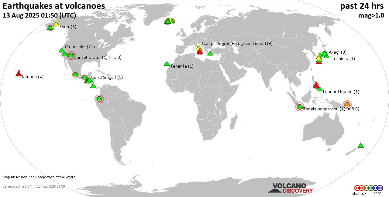
Wed, 13 Aug 2025, 01:50 | BY: EARTHQUAKEMONITOR
World map showing volcanoes with shallow (less than 50 km) earthquakes within 20 km radius during the past 24 hours on 13 Aug 2025 Number in brackets indicate nr of quakes.
Quakes detected near: Akagi (3 quakes between mag 0.2-1.5), Aso (1 quake mag 1.7), Barva (1 quake mag 1.8), Brennisteinsfjöll (3 quakes between mag 0.1-1.3), Campi Flegrei (Phlegrean Fields) (9 quakes between mag 0.1-1.1), Canlaon (3 quakes between mag 2.1-2.8)
Cerro Singüil (1 quake mag 2.4), Clear Lake (21 quakes between mag 0.0-1.6), Coso (3 quakes between mag 0.3-1.1), Daisen (2 quakes between mag 0.4-1.3), Denison (1 quake mag 2.1), El Chichón (3 quakes between mag 2.3-2.5), Eldey (2 quakes between mag 1.7-2.0), Etna (5 quakes between mag 1.1-2.0), Guagua Pichincha (1 quake mag 3.5), Hiuchi (3 quakes between mag 0.4-1.1), Hualalai (1 quake mag 1.5), Ibusuku (3 quakes between mag 0.6-1.3), Katla (7 quakes between mag 0.3-2.3), Kilauea (4 quakes between mag 1.7-1.8), Kolumbo (2 quakes between mag 1.3-1.8), Krísuvík (8 quakes between mag 0.4-1.8), Kuju (3 quakes between mag 0.8-2.6), Langjökull (1 quake mag 1.1), Leonard Range (1 quake mag 1.6), Ljósufjöll (8 quakes between mag 0.1-1.4), Loki-Fögrufjöll volcano (5 quakes between mag 0.4-2.1), Michoacán-Guanajuato (8 quakes between mag 1.9-2.8), Moyuta (1 quake mag 2.7), Myoko (1 quake mag 1.7), Prestahnukur (1 quake
Click this link to continue reading the article on the source website.