RSS feed source: US National Weather Service

* WHAT…Small stream flooding caused by excessive rainfall is expected. * WHERE…A portion of central California, including the following county, Fresno. * WHEN…Until 1000 AM PDT. * IMPACTS…Minor flooding in low-lying and poor drainage areas. * ADDITIONAL DETAILS… – At 700 AM PDT, Doppler radar indicated heavy rain due to thunderstorms. This will cause small stream flooding. – Some locations that will experience flooding include… Yokuts Valley. – http://www.weather.gov/safety/flood

Click this link to continue reading the article on the source website.

RSS feed source: US National Weather Service

…The Flood Warning continues for the following rivers in South Dakota… James River near Stratford affecting Spink and Brown Counties. .For sites with a river forecast, the forecast includes precipitation through the next 24 hours. Any future precipitation could affect the forecasts. * WHAT…Minor flooding is occurring and minor flooding is forecast. * WHERE…James River near Stratford. * WHEN…Until further notice. * IMPACTS…At 14.0 feet, Significant amounts of agricultural lands begin flooding. * ADDITIONAL DETAILS… – At 7:45 AM CDT Tuesday the stage was 14.0 feet. – Recent Activity…The maximum river stage in the 24 hours ending at 7:45 AM CDT Tuesday was 14.0 feet. – Forecast…The river is expected to

Click this link to continue reading the article on the source website.

RSS feed source: US National Weather Service

…The Flood Warning continues for the following rivers in Oklahoma… Cimarron River near Waynoka affecting Major, Woods and Woodward Counties. * WHAT…Minor flooding is forecast. * WHERE…Cimarron River near Waynoka. * WHEN…From this evening to tomorrow morning. * IMPACTS…At 8.0 feet, Bankfull conditions exist along the river… and some overflows may occur over some low-lying areas near the river. The river reach affected extends from near Freedom upstream… to the U.S. Highway 281 crossing south of Little Sahara State Park near Waynoka… to near Orienta in Major County. * ADDITIONAL DETAILS… – At 8:30 AM CDT Tuesday the stage was 6.9 feet. – Bankfull stage is 8.0 feet. – Forecast…The river

Click this link to continue reading the article on the source website.

RSS feed source: US National Weather Service

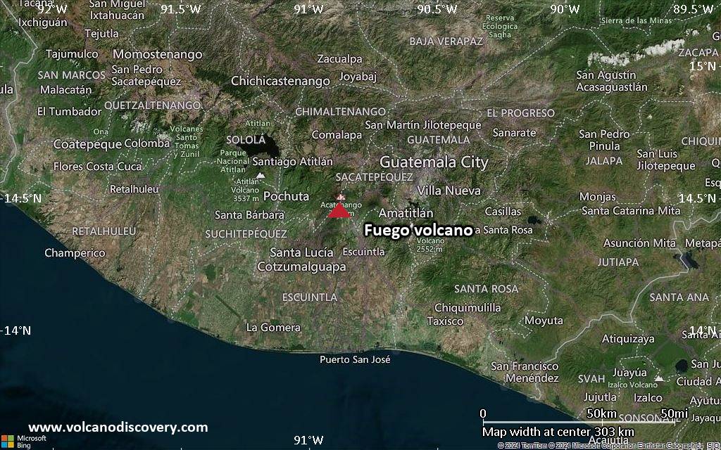
<!–div style="font-size:14px;text-align:center;border:3px solid blue;border-radius:5px;padding:3px;margin:5px;background:#eee"><a href="https://www.volcanoesandearthquakes.com/app/volcano-report.php?volcanoId=26" style="text-decoration:none" target="_blank" rel="noopener noreferrer nofollow" title="Share a volcano (activity) report, submit a photo or other interesting news!” onclick=”window.open(this.href,’Volcano Report’,’status=0,toolbar=0,location=0,directories=0,menubar=0,resizable=1,scrollbars=1,height=500,width=450′);return false”>Send Volcano Report</div–> Stratovolcano 3,763 m / 12,346 ft
Guatemala, 14.47°N / -90.88°W
Current status: erupting (4 out of 5) Fuego volcano eruptions:
1581, 1585, 1586, 1587, 1614, 1617, 1620, 1623, 1629, 1679(?), 1685, 1686, 1689(?), 1699, 1702, 1705, 1706, 1709(?), 1710,1717,1730, 1732, 1737, 1751(?), 1765(?), 1773(?), 1799, 1826, 1829, 1850(?), 1852(?), 1855, 1856, 1857, 1860, 1861(?), 1867(?), 1880, 1896, 1932, 1944, 1949, 1953, 1955, 1957, 1962, 1963, 1966, 1967, 1971, 1973, 1974, 1975, 1977, 1987, 1999, 2002 – ongoing
Typical eruption style
Dominantly explosive, construction of lava domes and extrusion of viscous lava flows. In near constant activity, at least during the past centuries.

Click this link to continue reading the article on the source website.