RSS feed source: US National Weather Service

* WHAT…Flooding caused by excessive rainfall continues. * WHERE…Southeastern portions of Hale County in northwest Texas. * WHEN…Until 1030 PM CDT. * IMPACTS…Minor flooding in low-lying and poor drainage areas. Water over roadways. * ADDITIONAL DETAILS… – At 912 PM CDT, Doppler radar and automated rain gauges indicated the heavy rain has ended. However, overflowing poor drainage areas have already caused minor flooding in the advisory area and slow drainage is expected to prolong minor flooding. Up to 3 inches of rain have fallen. – Some locations that will experience flooding include… Abernathy and Petersburg. – http://www.weather.gov/safety/flood

Click this link to continue reading the article on the source website.

RSS feed source: US National Weather Service

At 812 PM MDT, Doppler radar was tracking a strong thunderstorm 8 miles north of Haswell, or 44 miles northeast of North La Junta, moving southeast at 25 mph. HAZARD…Wind gusts up to 50 mph and half inch hail. SOURCE…Radar indicated. IMPACT…Gusty winds could knock down tree limbs and blow around unsecured objects. Minor hail damage to vegetation is possible. Locations impacted include… Haswell.

Click this link to continue reading the article on the source website.
RSS feed source: US National Weather Service

* WHAT…Flooding caused by excessive rainfall is expected. * WHERE…A portion of west central Texas, including the following county, Crockett. * WHEN…Until 1100 PM CDT. * IMPACTS…Minor flooding in low-lying and poor drainage areas. Water over roadways. * ADDITIONAL DETAILS… – At 908 PM CDT, Doppler radar indicated heavy rain due to thunderstorms. Minor flooding is ongoing or expected to begin shortly in the advisory area. Between 0.75 and 1.5 inches of rain have fallen. – Additional rainfall amounts of 0.5 to 1 inch are expected over the area. This additional rain will result in minor flooding. – Some locations that will experience flooding include… mainly rural areas of North Central

Click this link to continue reading the article on the source website.

RSS feed source: US National Weather Service

Sun, 31 Aug 2025, 01:50 | BY: EARTHQUAKEMONITOR

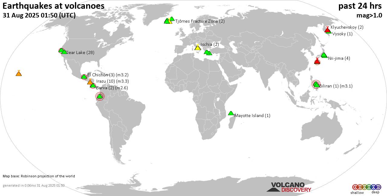
World map showing volcanoes with shallow (less than 50 km) earthquakes within 20 km radius during the past 24 hours on 31 Aug 2025 Number in brackets indicate nr of quakes.

Quakes detected near: Akuseki-jima (2 quakes between mag 2.2-2.2), Barva (2 quakes between mag 1.2-2.6), Biliran (1 quake mag 3.1), Cabalian (2 quakes between mag 2.3-3.1), Campi Flegrei (Phlegrean Fields) (9 quakes between mag 0.1-1.2), Clear Lake (28 quakes between mag 0.2-2.0)
El Chichón (3 quakes between mag 2.1-3.2), Eyafjallajökull (2 quakes between mag 0.6-1.1), Galeras (1 quake mag 3.6), Hakone (1 quake mag 1.1), Irazu (10 quakes between mag 0.8-3.3), Ischia (2 quakes between mag 1.3-1.4), Katla (15 quakes between mag 0.0-2.2), Kilauea (1 quake mag 1.8), Klyuchevskoy (2 quakes between mag 1.5-1.7), Kolumbo (4 quakes between mag 0.8-1.8), Krísuvík (17 quakes between mag 0.0-3.1), Ljósufjöll (5 quakes between mag 0.0-1.3), Long Valley (1 quake mag 2.4), Mayotte Island (1 quake mag 1.4), Methana (1 quake mag 1.8), Mt Fuji (1 quake mag 1.1), Nii-jima (4 quakes between mag 1.0-1.8), Suwanose-jima (1 quake mag 1.6), Telica (2 quakes between mag 1.0-1.2), Tjörnes Fracture Zone (2 quakes between mag 0.5-1.3), To-shima (1 quake mag 2.2), Vesuvius (4 quakes between mag 0.1-1.5), Vysoky (1 quake mag 1.8) (updated 01h50)

Note: Earthquakes within 20 km from and

Click this link to continue reading the article on the source website.