RSS feed source: USGS Earthquake Hazards Program
Time2025-11-26 10:59:27 UTC2025-11-26 10:59:27 UTC at epicenterLocation7.119°S 129.833°EDepth145.21 km (90.23 mi)
Click this link to continue reading the article on the source website.
RSS feed source: USGS Earthquake Hazards Program
Time2025-11-26 10:59:27 UTC2025-11-26 10:59:27 UTC at epicenterLocation7.119°S 129.833°EDepth145.21 km (90.23 mi)
Click this link to continue reading the article on the source website.
RSS feed source: USGS Earthquake Hazards Program
Time2025-11-26 10:49:14 UTC2025-11-26 10:49:14 UTC at epicenterLocation37.920°S 73.980°WDepth24.24 km (15.06 mi)
Click this link to continue reading the article on the source website.
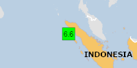
RSS feed source: USGS Earthquake Hazards Program
PAGER – GREEN ShakeMap – VII DYFI? – VII
Time2025-11-27 04:56:26 UTC2025-11-27 04:56:26 UTC at epicenterLocation2.692°N 96.027°EDepth25.39 km (15.78 mi)
Click this link to continue reading the article on the source website.
RSS feed source: USGS Earthquake Hazards Program
On 11/27/2025 4:56:26 AM, an earthquake occurred in Indonesia potentially affecting 10 thousand (in MMI>=VII). The earthquake had Magnitude 6.6M, Depth:25.388km.
Click this link to continue reading the article on the source website.