PAGER – YELLOW ShakeMap – VI DYFI? – V
Time2026-01-02 13:58:18 UTC2026-01-02 13:58:18 UTC at epicenterLocation16.902°N 99.303°WDepth35.00 km (21.75 mi)
PAGER – YELLOW ShakeMap – VI DYFI? – V
Time2026-01-02 13:58:18 UTC2026-01-02 13:58:18 UTC at epicenterLocation16.902°N 99.303°WDepth35.00 km (21.75 mi)
<!–div style="font-size:14px;text-align:center;border:3px solid blue;border-radius:5px;padding:3px;margin:5px;background:#eee"><a href="https://www.volcanoesandearthquakes.com/app/volcano-report.php?volcanoId=2868" style="text-decoration:none" target="_blank" rel="noopener noreferrer nofollow" title="Share a volcano (activity) report, submit a photo or other interesting news!” onclick=”window.open(this.href,’Volcano Report’,’status=0,toolbar=0,location=0,directories=0,menubar=0,resizable=1,scrollbars=1,height=500,width=450′);return false”>Send Volcano Report</div–> caldera 635 m / 2,083 ft
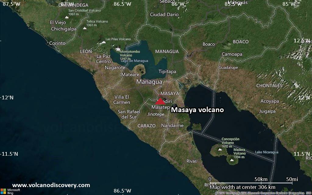
Nicaragua, 11.98°N / -86.16°W
Current status: erupting (4 out of 5) Masaya volcano eruptions:
2012, 2008, 2006, 2005, 2004 (?), 2003, 2001, 1999-2000, 1998, 1997, 1996, 1993-94, 1989, 1987, 1965-85, 1948, 1946-47, 1925, 1919-24, 1918, 1913, 1906, 1904, 1902-03, 1858-59, 1858 (?), 1856-57, 1853, 1852, 1772, 1670, 1613 (?), 1586, 1570, 1551, 1524-44
Tephrochronology and radiocarbon-dated: 150 AD, 170 BC ± 100 years, 4050 BC
Typical eruption style
effusive, sometimes lava lakes, strombolian activity
22 km (14 mi)
W of epicenter
(pop: 2,370)
III: Weak
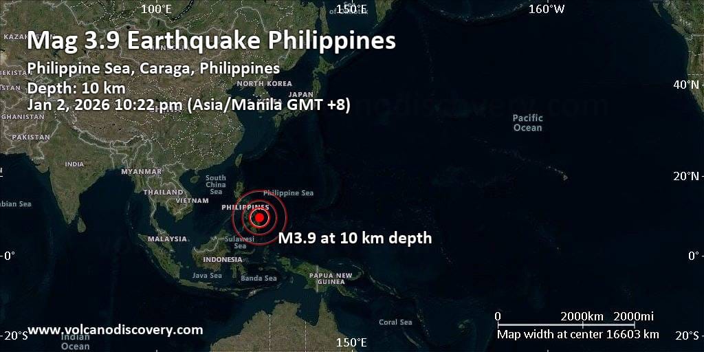
Province of Surigao del Norte, Caraga 25 km (16 mi)
NW of epicenter
(pop: 2,390)
III: Weak
Province of Surigao del Norte, Caraga 28 km (18 mi)
W of epicenter
(pop: 8,820)
III: Weak
Province of Surigao del Norte, Caraga 39 km (24 mi)
W of epicenter
(pop: 4,280)
III: Weak
Province of Surigao del Norte, Caraga 39 km (24 mi)
NW of epicenter
(pop: 2,330)
III: Weak
Province of Surigao del Norte, Caraga 41 km (26 mi)
SW of epicenter
(pop: 9,740)
III: Weak
Province of Surigao del Norte, Caraga 58 km (36 mi)
S of epicenter
(pop: 3,510)
II: Very weak
Province of Surigao del Sur, Caraga 60 km (38 mi)
SW of epicenter
(pop: 2,550)
II: Very weak
Province of Surigao del Sur, Caraga 61 km (38 mi)
SW of epicenter
(pop: 9,410)
II: Very weak
Province of Surigao del Sur, Caraga 67 km (42 mi)
W of epicenter
(pop: 5,910)
II: Very weak
Province of Surigao del Norte, Caraga 69 km (43 mi)
SW of epicenter
(pop: 2,810)
II: Very weak
Province of Surigao del Sur, Caraga 72 km (45
On 1/2/2026 1:58:18 PM, an earthquake occurred in Mexico potentially affecting 270 thousand in MMI VI. The earthquake had Magnitude 6.5M, Depth:35km.