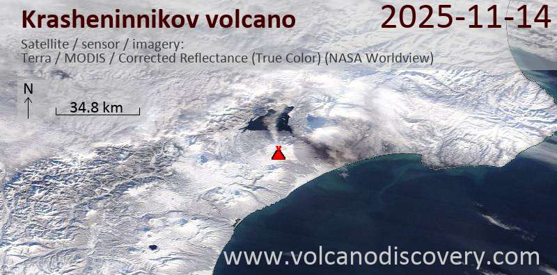
RSS feed source: USGS Earthquake Hazards Program
Time2025-11-13 08:27:28 UTC2025-11-13 08:27:28 UTC at epicenterLocation23.446°S 66.610°WDepth209.12 km (129.94 mi)
Click this link to continue reading the article on the source website.
RSS feed source: USGS Earthquake Hazards Program
Time2025-11-13 08:27:28 UTC2025-11-13 08:27:28 UTC at epicenterLocation23.446°S 66.610°WDepth209.12 km (129.94 mi)
Click this link to continue reading the article on the source website.
RSS feed source: USGS Earthquake Hazards Program
Support Us – Help Us Enhance Our Services! We’re passionate about delivering the latest volcano and earthquake data from around the globe — just for you. However, maintaining our website and free apps requires significant time, effort, and resources.
Your support helps us expand our hardware and software capabilities and empowers our dedicated editorial team. Our mission is to provide uninterrupted, real-time updates whenever an earthquake strikes or a volcano erupts — and your donations make this possible. Every contribution, big or small, is deeply appreciated. If you find our information valuable and want to help us add new features, create compelling content, and improve our technology, please consider making a donation: Donate with PayPal: Planned Features: Improved multilingual support Tsunami alerts Faster responsiveness Thanks to your past donations, we have recently added: Design upgrades Detailed earthquake
Click this link to continue reading the article on the source website.
RSS feed source: USGS Earthquake Hazards Program
49 km (30 mi)
NW of epicenter
(pop: 2,630)
II: Very weak
Departamento de Belen, Catamarca Province 57 km (36 mi)
S of epicenter
(pop: 13,700)
II: Very weak
La Rioja Province 60 km (37 mi)
N of epicenter
(pop: 1,070)
II: Very weak
Departamento de Belen, Catamarca Province 70 km (44 mi)
W of epicenter
(pop: 14,500)
II: Very weak
Catamarca Province 72 km (45 mi)
SE of epicenter
(pop: 3,390)
II: Very weak
Departamento de Poman, Catamarca Province 74 km (46 mi)
E of epicenter
(pop: 1,210)
II: Very weak
Departamento de Poman, Catamarca Province 75 km (47 mi)
NE of epicenter
(pop: 14,100)
II: Very weak
Departamento de Andalgala, Catamarca Province 88 km (54 mi)
NW of epicenter
(pop: 8,060)
II: Very weak
Departamento de Tinogasta, Catamarca Province 94 km (58 mi)
N of epicenter
(pop: 2,300)
II: Very weak
Departamento de Belen, Catamarca Province 97 km (60 mi)
E of epicenter
(pop: 1,080)
II: Very weak
Departamento de Ambato, Catamarca Province 97 km (60 mi)
E of epicenter
(pop: 1,910)
II: Very weak
Departamento de Ambato, Catamarca Province 112 km (70 mi)
E of epicenter
(pop: 4,290)
II: Very weak
Click this link to continue reading the article on the source website.
RSS feed source: USGS Earthquake Hazards Program
* WHAT…Flooding caused by excessive rainfall is expected. * WHERE…Western San Luis Obispo and Santa Barbara Counties. * WHEN…Until 1130 PM PST. * IMPACTS…Minor flooding in low-lying and poor drainage areas. Water over roadways. * ADDITIONAL DETAILS… – At 826 PM PST, Doppler radar indicated heavy rain. Minor flooding is ongoing or expected to begin shortly in the advisory area. Between 0.5 and 1.5 inches of rain have fallen thus far. The greatest impacts are expected for the western Santa Ynez Range and adjacent coasts near Point Conception and Point Arguello. – Some locations that will experience flooding include… Santa Maria, San Luis Obispo, Lompoc, Paso Robles, Morro Bay, Pismo Beach,
Click this link to continue reading the article on the source website.