RSS feed source: US National Weather Service

…The Flood Warning is extended for the following rivers in West Virginia…Maryland… Potomac River at Hancock affecting Washington and Morgan Counties. Potomac River at Shepherdstown affecting Washington, Berkeley and Jefferson Counties. Opequon Creek near Martinsburg affecting Berkeley and Jefferson Counties. …The Flood Warning continues for the following rivers in West Virginia…Maryland… Potomac River at Paw Paw affecting Morgan, Hampshire and Allegany Counties. Cacapon River near Great Cacapon affecting Morgan County. North Branch Potomac River Near Cumberland affecting Mineral, Hampshire and Allegany Counties. Georges Creek at Westernport affecting Allegany County. Wills Creek near Cumberland affecting Allegany County. For the North Branch Potomac River…including Kitzmiller, Luke, Cumberland…Major flooding is forecast. For the Potomac

Click this link to continue reading the article on the source website.

RSS feed source: US National Weather Service

Wed, 14 May 2025, 04:25 | BY: EARTHQUAKEMONITOR

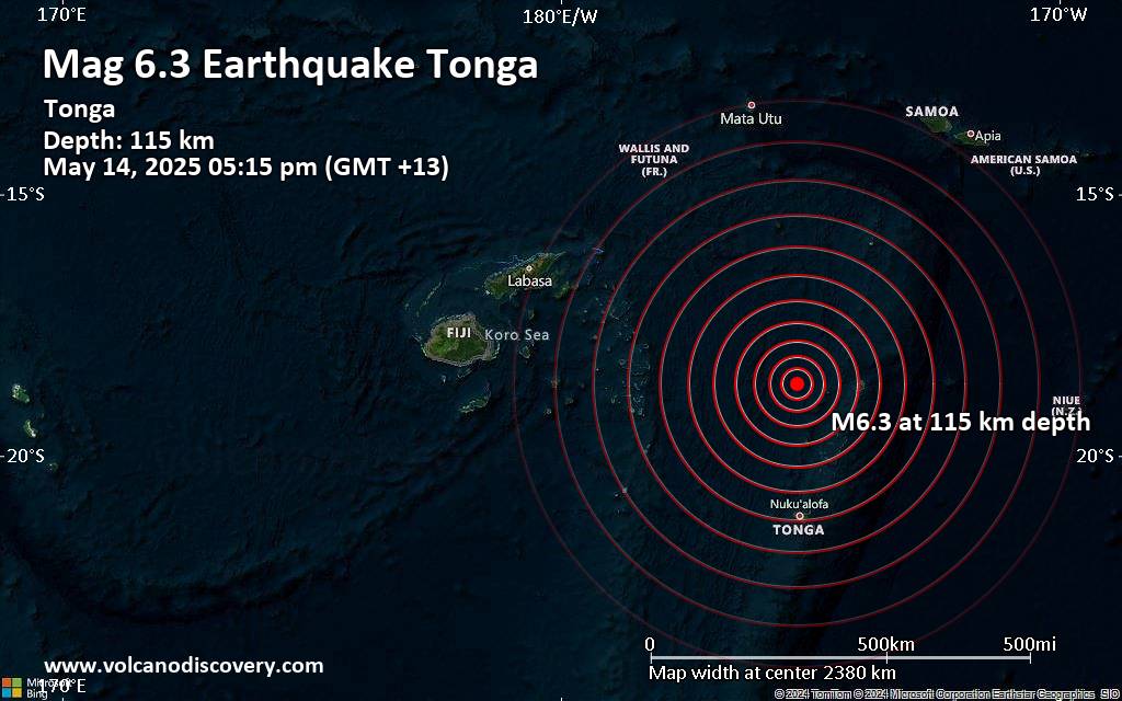
An intermediate magnitude 6.3 earthquake was reported in the afternoon near Neiafu, Vava’u, Tonga.
According to the European-Mediterranean Seismological Centre (EMSC), the quake hit on Wednesday, May 14th, 2025, at 5:15 pm local time at an intermediate depth of 115. km. The strength of the earthquake may have been tempered by its relative great depth below the surface, which makes it feel weaker in absolute terms. The exact magnitude, epicenter, and depth of the quake might be revised within the next few hours or minutes as seismologists review data and refine their calculations, or as other agencies issue their report.
A second report was later issued by France’s Réseau National de Surveillance Sismique (RéNaSS), which listed it as a magnitude 6.2 earthquake. A third agency, the German Research Centre for Geosciences (GFZ), reported the same quake at magnitude 5.9.
Based on the preliminary seismic data, the quake was probably felt by many people in the area of the epicenter. It should not have caused significant damage, other than objects falling from shelves, broken windows, etc.
In Neiafu (pop. 4,300) located 135 km from the epicenter, the quake should have been felt as light shaking.
VolcanoDiscovery will automatically update magnitude and depth if these change and follow up if other significant news about the quake become available. If you’re

Click this link to continue reading the article on the source website.
RSS feed source: US National Weather Service

Date and TimeMag
DepthDistanceLocationDetailsMap May 6, 08:49 pm (GMT +13)

4.6

254 km103 km (64 mi) to the N 169 km WNW of Neiafu, Tonga InfoApr 20, 01:38 am (GMT +13)

4.5

203 km36 km (23 mi) to the NW South Pacific Ocean, 139 km north of Tofua Island, Ha`apai, Tonga InfoApr 3, 02:58 am (GMT +13)

4.3

284 km61 km (38 mi) to the N 116 km WNW of Neiafu, Tonga InfoMar 31, 01:18 am (GMT +13)

7.0

29 km224 km (139 mi) to the SE South Pacific Ocean, 162 km northeast of Nuku’alofa, Tongatapu, Tonga 18 reportsInfoFeb 16, 09:25 am (Universal Time)

4.9

193 km40 km (25 mi) to the NW 153 km W of Neiafu, Tonga InfoJan 30, 12:10 am (GMT +13)

4.1

293 km97 km (60 mi) to the W South Pacific Ocean, 154 km northwest of Tofua Island, Ha`apai, Tonga InfoDec 16, 2024 04:03 am (GMT +13)

5.9

232 km5.5 km (3.4 mi) to the W South Pacific Ocean, 115 km north of Tofua Island, Ha`apai, Tonga InfoMay 27, 2024 09:47 am (Tongatapu)

6.6

137 km78 km (48 mi) to the SE 70 km NW of Fangale’ounga, Tonga 11 reportsInfoJan 19, 2024 11:12 am (GMT +13)

6.4

209 km29 km (18 mi) to the SW 114 Km WSW of Neiafu, Tonga 6 reportsInfoDec 11, 2023 07:33 pm (GMT +13)

6.2

248 km47 km (29 mi) to the W 174 km NW of Fangale’ounga, Tonga 1 reportInfoJul 2, 2023 11:27 pm (GMT +13)

6.9

229 km100 km (62 mi) to the N Tonga 13 reportsInfoMay 27, 2023 01:11 pm (GMT +13)

6.0

222 km29 km (18 mi) to the N Tonga 1 reportInfoJun 5, 2022 02:07 am (GMT +13)

6.3

237 km91 km

Click this link to continue reading the article on the source website.

RSS feed source: US National Weather Service

Support us – Help us upgrade our services! We truly love working to bring you the latest volcano and earthquake data from around the world. Maintaining our website and our free apps does require, however, considerable time and resources.
We need financing to increase hard- and software capacity as well as support our editor team. We’re aiming to achieve uninterrupted service wherever an earthquake or volcano eruption unfolds, and your donations can make it happen! Every donation will be highly appreciated. If you find the information useful and would like to support our team in integrating further features, write great content, and in upgrading our soft- and hardware, please make a donation (PayPal).

Planned features:

Improved multilanguage supportTsunami alertsFaster responsivenessThanks to your past donations, these features have been added recently:Design upgradeDetailed quake statsAdditional seismic data sourcesDownload and Upgrade the Volcanoes & Earthquakes app to get one of

Click this link to continue reading the article on the source website.